| OCR Text |
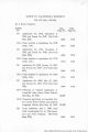
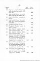
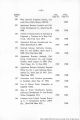
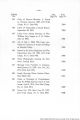
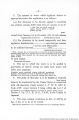
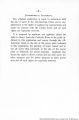
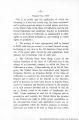
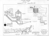
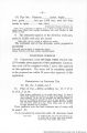
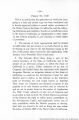
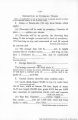
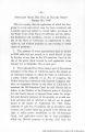
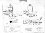
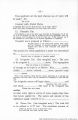
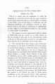
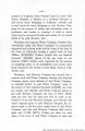
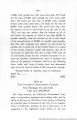
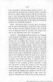
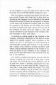
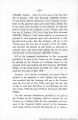
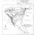
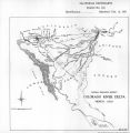
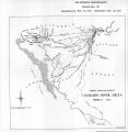
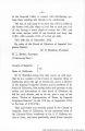
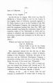
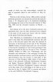
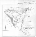
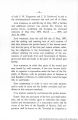
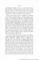
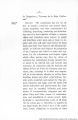
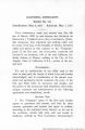
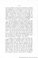
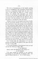
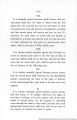
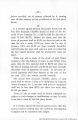
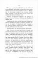
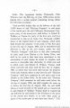
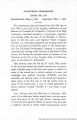
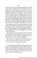
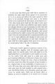
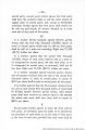
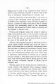
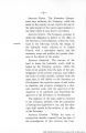
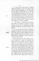
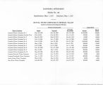
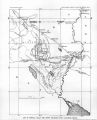
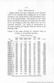
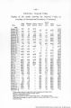
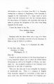
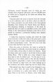
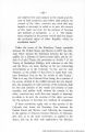
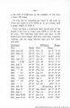
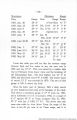
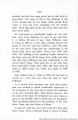
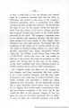
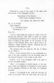
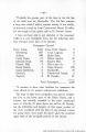
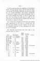
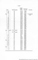
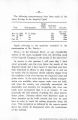
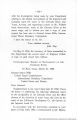
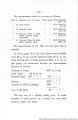
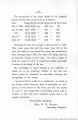
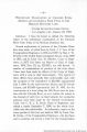
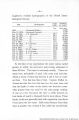
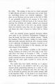
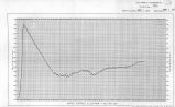
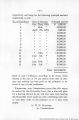
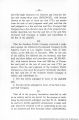
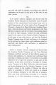
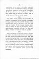
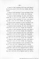
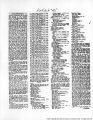
Show -31- to the Gulf of California by the meanders of the river is about 150 miles. On July 5th we measured the water in the river at Yuma and found it to be 18350 cu. ft. per second, with a gauge height of 2106 ft. There has been a continuous daily record kept of the height of the river at Yuma since 1878, or for the last 24 years. The following table gives the dates of the highest and lowest stages each year, with their respective readings, and the range between high and low water each year. Maximum. Minimum. Range. Date. Gauge. Date. Gauge. 1878, June 23 23' 0" Dec. 31 14' 8" 8' 4" 1879, May 12 W 0" Oct. 15 13' 2" 6'10" 1880 " 31 24' 0" Dec. 3-13 14'10" 9' 2" 1881, June 14 23' 5" Jan. 26 15' 0" 8' 5" 1882, " 17-20 22' 7" Dec. 20 15' 6" 7' 1" 1883, July 3 24' 6" Dec. 14 14' 0" 10' 6" 1884, June 27 28' 6" Dec. 3-7 14' 2" 14' 4" 1885, " 13 24' 8" Feb. 8-9 13' 8" 11' 0" 1886, " 6-7 26' cy Jan. 19 14' 5" 12' 4" 1887, " 10-11 23' 6" Jan. 26-27 14'10" 8' 8" 1888, " 24-26 21': L0" Jan. 4 14' 9" 7' 1" 1889, " 7-8 22' 4" Sep. 27 15' 5" 6'J 1890, " 5 25' 6" Jan. 29 16'5" 9' 1" 1891, Feb. 26 33' 2" (From Gila) 16' 9" 1891, May 17 25' 0" Sep. 22-23 16' 5" 8' 7" 1892, July 3 25' 6" Dec. 31 15' 6" 10' 0" 1893, May 28-29 25' 2" Jan. 1-3 15' 6" c/ 8" 1894, June 14-15 23' 8" Jan. 21-25 15'10" 7'10" |
| Source |
Original book: [State of Arizona, complainant v. State of California, Palo Verde Irrigation District, Coachella Valley County Water District, Metropolitan Water District of Southern California, City of Los Angeles, California, City of San Diego, California, and County of San Diego, California, defendants, United States of America, State of Nevada, State of New Mexico, State of Utah, interveners] : California exhibits. |