Contents | 137 of 399


page 6


| Title | AZ vs. CA:03 California Exhibits, Vol III; Nos. 114-150 |
| Creator | Arizona, complainant.; California, ; defendant.; Palo Verde Irrigation District (Calif.), ; defendant.; United States.; Supreme Court. |
| Subject | Water rights; Water consumption; Rivers |
| Date | 1958 |
| Type | Text |
| Format | application/pdf |
| Digitization Specifications | Pages were scanned at 400 ppi on Fujitsu fi-5650C sheetfed scanner as 8-bit grayscale or 24-bit RGB uncompressed TIFF images. For ContentDM access the images were resampled to 750 pixels wide and 120 dpi and saved as JPEG (level 8) in PhotoShop CS with Unsharp Mask of 100/.3. Foldout pages larger than 11" x 14" were captured using a BetterLight Super 8K-2 digital camera back on a 4x5 view camera (100mm Schneider APO lens). Oversize images were resampled to 1500 pixels wide. Optical Character Recognition (OCR) by ABBYY FineReader 7.0 with manual review. |
| Language | eng |
| Rights Management | Digital Image Copyright 2005, University of Utah. All Rights Reserved. |
| Holding Institution | 5th Special Coll. Rare, University Library, California State University, Long Beach |
| Source Physical Dimensions | 25 v. : ill. (some folded) ; 25 cm. |
| Scanning Contractor | Backstage Library Works - 1180 S. 800 E. Orem, UT 84097. |
| Call Number | KF5575.A55 A72 |
| ARK | ark:/87278/s6sj1jgf |
| Setname | wwdl_azvca |
| ID | 1128361 |
| Reference URL | https://collections.lib.utah.edu/ark:/87278/s6sj1jgf |
Page Metadata
| Title | page 6 |
| Format | application/pdf |
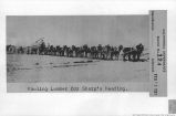
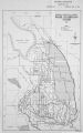
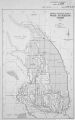
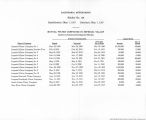
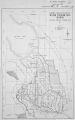
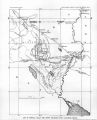
| Source | Original book: [State of Arizona, complainant v. State of California, Palo Verde Irrigation District, Coachella Valley County Water District, Metropolitan Water District of Southern California, City of Los Angeles, California, City of San Diego, California, and County of San Diego, California, defendants, United States of America, State of Nevada, State of New Mexico, State of Utah, interveners] : California exhibits. |
| Resource Identifier | 030206-UUM-AvC-v3t132_page 6.jpg |
| Setname | wwdl_azvca |
| ID | 1128098 |
| Reference URL | https://collections.lib.utah.edu/ark:/87278/s6sj1jgf/1128098 |