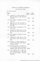
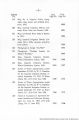
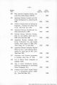
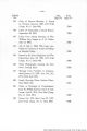
| OCR Text |
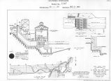
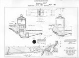
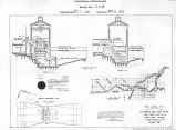
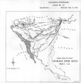
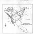
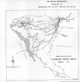
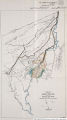
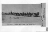
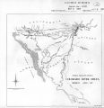
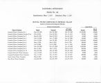
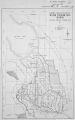
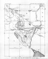
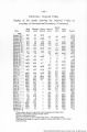
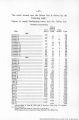
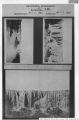
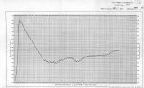
Show Summary. The Colorado River, between Yuma and Camp Mojave, about 300 miles is generally navigable, though with more or less difficulty at all seasons of the year. It has been shown that most of the Ehrenberg trade will disappear during the coming summer; leaving it out therefore, the freight carried to and from all points on this portion of the river has, during the past two years, averaged less than 300 tons per month. The principal obstructions to navigation being the shoal and shifting channels in the valleys, no plan will give any permanent change for the better unless it provides for the entire and certain confinement and control of more than 200 miles of river, while there is manifestly no present justification for so vast an expenditure as the execution of such a plan would entail. Improvements, however, could be effected, and would probably be permanent, at certain gravel bars for about $13,000. The section of the river between Camp Mojave and El Dorado Canon can at present be navigated for more than three months in the year, and throughout it, low-water navigation could probably be provided for about $90,000, though unforeseen contingencies might increase that amount. Most of the freight which seeks to go above Camp Mojave is for Hardyville, while the distances between the two places is only 7 miles and traversed by a good road. During the entire 19 months preceding January 1, 1879, less than 100 tons was transported from below to points above Hardyville, the principal and only important reason |
| Source |
Original book: [State of Arizona, complainant v. State of California, Palo Verde Irrigation District, Coachella Valley County Water District, Metropolitan Water District of Southern California, City of Los Angeles, California, City of San Diego, California, and County of San Diego, California, defendants, United States of America, State of Nevada, State of New Mexico, State of Utah, interveners] : California exhibits. |