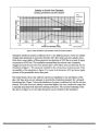
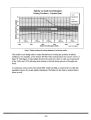
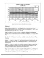
| OCR Text |
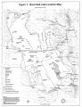
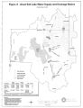
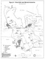
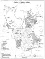
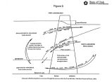
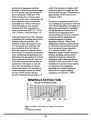
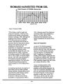
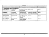
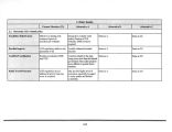
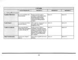
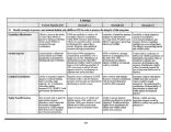
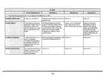
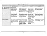
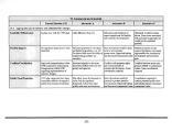
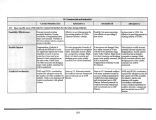
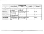
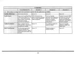
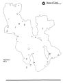
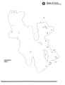
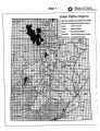
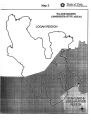
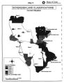
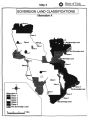
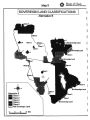
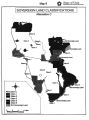
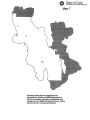
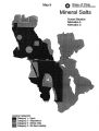
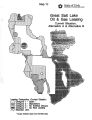
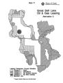
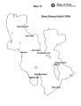
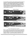
Show Class 2: Manage to protect potential resource development options. Class 3: Manage as open for consideration of any use. Class 4: Manage for resource inventory and analysis. Class 5: Manage to protect potential resource preservation options. Class 6: Manage to protect existing resource preservation uses. The legislature has authorized DWR to use sovereign land in all or parts of 39 townships on GSL for the creation, operation, maintenance and management of WMAs, fishing waters and other recreational activities. This geographic area covers Bear River Bay, Ogden Bay, Farmington Bay, portions of the south shore area and the north end of Spring Bay. This statutory authorization is interpreted as establishing wildlife management and wildlife- related recreation as the primary intended land use, except for areas identified for other uses through a planning process. Land uses with significant adverse impacts on wildlife and recreation values may be prohibited, even though mitigation strategies are available. Some of this sovereign land is included in AISP and is managed by DPR. Some of the land has been sold or exchanged. The most current statement of use classifications for the sovereign and other state lands of GSL appears in the 1995 plan. The 1995 plan recommended application of the use classifications set forth in R652- 70- 200 to areas of GSL as follows ( See Appendix G, Map 3.): Class 1, managed to protect existing resource development Lands under this classification include the area around Antelope Island delegated to DPR for recreation management, the area around Saltair and GSL Marina, existing mineral extraction lease areas, and areas under special use lease for brine shrimp cyst harvest activities. These lands would be open to oil and gas leasing, but no surface occupancy will be allowed in the recreation areas. Class 2, managed to protect potential resource development options. This area includes the West Rozel oil field and shoreline areas from the north end of Stansbury Island south along the west side of the island and then north along the west side of the lake to the south line of Township 11 North, Salt Lake Base and Meridian ( SLB& M). This area will be open to mineral leasing, developed recreation and other kinds of developments. Class 5, managed to protect potential resource preservation options. This classification includes lands which the legislature has authorized DWR to use for wildlife purposes under Section 23- 21- 5 ( See Map 7), and a one- mile buffer zone around islands in the north arm of the lake. No surface occupancy for oil and gas exploration will be allowed in established WMAs or in the island buffer zones. Elsewhere, oil and gas surface occupancy constraints shall be determined in consultation with DWR. Mitigation strategies for developments not related to wildlife 114 |