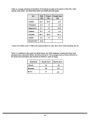
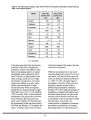
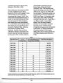
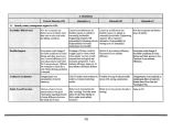
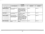
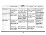
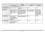
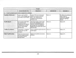
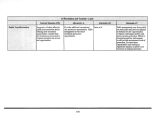
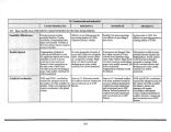
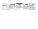
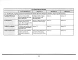
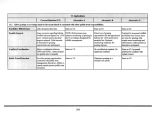
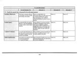
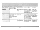
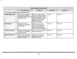
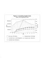
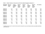
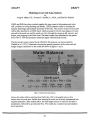
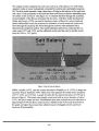
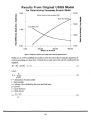
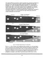
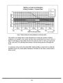
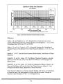
| OCR Text |
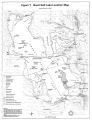
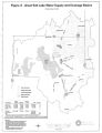
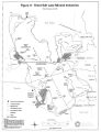
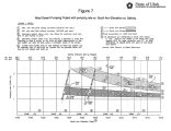
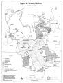
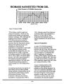
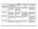
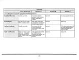
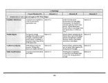
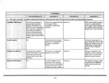
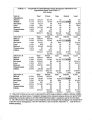
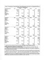
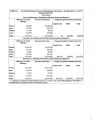
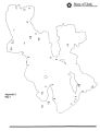
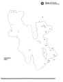
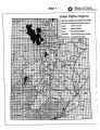
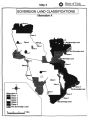
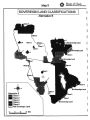
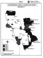
Show development of Ogden Bay WMA started in 1937 with a cooperative project between DWR, Weber County Wildlife Federation, USFWS and the Civilian Conservation Corps. In 1938, following the passage of the Pittman- Robertson Act, Ogden Bay became the nation's first Federal Aid to Wildlife restoration project. It is located two miles west and one mile north of Hooper in Davis and Weber Counties. Ogden Bay WMA contains the following habitat types ( acreage numbers are estimated): 4,998 acres open water 4,780 acres marsh 5,182 acres mudflats 3,800 acres uplands Ogden Bay WMA is also known for wildlife- related recreation on GSL. During the production period, March 1 through August 1, approximately 15 miles of dikes are open to non- motorized use. Throughout the rest of the year, 45 miles of dikes are open to non- motorized use. Several air boat ramps and parking areas are available for public use at various lake levels during the hunting season. Ogden Bay WMA has approximately 70,000 visitors each year, 28,000 of which are waterfowl hunters and the rest are other wildlife enthusiasts. The most popular activities include wildlife watching and waterfowl hunting. Ogden Bay WMA's wetland resource values are dependent on the water levels of GSL. A series of boat ramps which are useable at various lake levels improve access. Wetland habitat, wildlife use and public recreation opportunities are greatly reduced at high lake level elevations. During the 1980s flooding, wildlife and human use decreased by over 90 percent. Lake level begins to affect Ogden Bay WMA dikes at a lake level elevation of 4203 feet, which occurred in 1998. Other dike elevations range from 4205- 4212 feet, with upland areas at an elevation of 4220 feet. More than 80 percent of the area is flooded at a lake elevation of 4211 feet. Flood damages to the diking system were close to $ 150,000 in the 1980s. Important issues for Howard Slough and Ogden Bay WMAs include vulnerability to flooding from the Weber River and GSL. Other management issues include additional access for air boats, visitor conflicts, water quality and high levels of sediment entering via the Weber River. The water rights are sufficient since this is one of the oldest WMAs in Utah. Another concern is diminishing agricultural habitat and food sources for White- faced ibis, waterfowl and other agriculturally- dependent species due to residential housing development on the periphery of the management area. Timpie Springs Waterfowl Management Area Timpie Springs WMA is located one mile north of 1- 80 at Rowley Junction, 15 miles northwest of Grantsville in Tooele County. This WMA is comprised of 1,440 acres. The water source is a saline spring which feeds two water impoundments created by 3.5 miles of dike. The salinity of the water source limits the vegetation of the area to salt grass. Waterfowl, waterbirds and shorebirds utilize this area. It is important because there are few significant marshes and sources of fresher water around the southwest quadrant of the lake. Bass and mosquito fish may be found in the springs. There is a half- mile long road that provides access to the area from 1- 80. This road terminates in a parking lot where there are informational signs. Timpie Springs has approximately 400 annual visitors, of which approximately 87 |