| OCR Text |
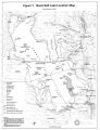
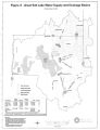
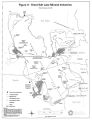
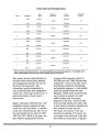
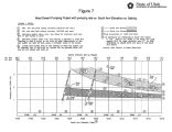
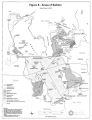
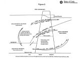
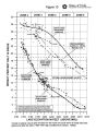
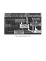
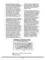
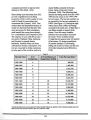
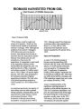
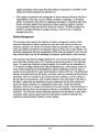
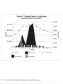
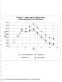
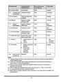
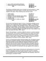
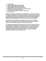
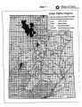
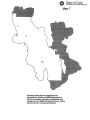
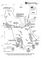
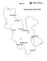
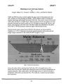
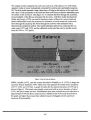
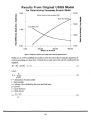
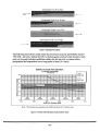
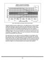
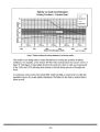
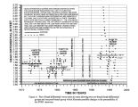
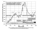
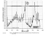
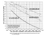
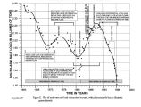
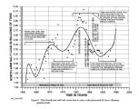
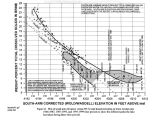
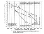
Show Water - Hydrology The " Hydrology" section addresses matters relating to the physical hydrology of GSL, including lake water level, inflows, flooding and diversions. The information collected during the scoping process highlighted three general areas of interest and concern with regard to the hydrology of the lake: lake level, including both low water levels and flooding potential; inflows to the lake, including flow quantities and locations; and diking and causeways in the lake, which affect currents and in- lake water conditions. Dikes and causeways have significant impacts on lake hydrology and water chemistry. The most significant resource impacts of dikes and causeways are more directly related to water chemistry than to other factors. Based on the information gathered during scoping and the resource inventory, the planning team has identified five major conditions and trends for the hydrology of the lake which are relevant to future management: • Continued reduction in inflows is anticipated. Studies of the lake hydrology indicate that 100,000 acre- feet of additional depletions per year would lower the average lake level approximately one foot. • The statutory requirement to define the flood plain and develop strategies to deal with a fluctuating lake level needs to be addressed. • The WDPP can presently be used for mitigation of flood impacts when the south arm lake level reaches 4208 feet by pumping north arm brines. The WDPP stands ready to be utilized for mitigation, but administrative barriers to its operation, external to DNR, now exist. • Locomotive Springs is being impacted by decreasing water flows. This issue would require that the DNR develop strategies to mitigate and remediate this interstate situation. • DNR is interested in establishing a policy regarding inter- island diking and freshwater embayments. Changes to Inflows GSL is a remnant of Pleistocene Lake Bonneville, and occupies the lowest point in a 22,000 square mile drainage basin. The lake is a terminal lake with no outlet. This closed basin is formed by the drainages of the Bear, Weber and Jordan Rivers, plus drainage areas northwest and southwest of the lake. ( See Figure 2.) The average annual inflow to the lake, for the years from 1851 to 1996, has been approximately 3,684,500 acre- feet. Inflows originate from gaged or correlated stream flows ( 2,382,500 acre- feet); estimated un- gaged surface water ( 191,500 acre- feet); estimated un- gaged groundwater ( 107,500 acre- feet); and precipitation directly onto the lake surface ( 1,003,000 acre- feet) according to DWRe Great Salt Lake Simulation Model. ( See Figure 3.) The average total annual evaporation equals average annual 15 |