| OCR Text |
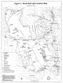
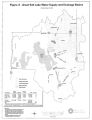
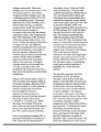
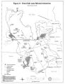
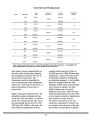
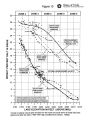
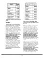
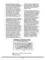
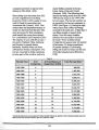
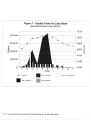
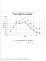
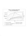
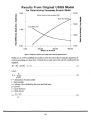
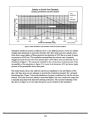
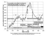
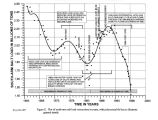
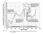
Show DNR has no regulatory authority over land DNR does not own in the flood plain. The regulatory framework is provided by local government planning and zoning, FEMA and U. S. Army Corps of Engineers ( COE). DNR satisfies the legislative mandate and policy by defining the flood plain for planning purposes as lands below 4217 feet and discouraging development below that level. FEMA has mapped the flood plain to determine when flood insurance is required. Adherence to FEMA's demarcation is required if local communities want to participate in the National Flood Insurance Program. COE regulates placement of fill material in wetlands. If a wetland lies within the flood plain as determined by COE, an additional criterion is added to the permit decision- making process. Agencies do not always agree on the extent of the flood plain. Flooding and the Operation of West Desert Pumping Project Lake Level Fluctuations and Flooding The historic hydrograph of GSL in Figure 5 is based on measurement at a series of lake gages since 1875 and on estimates of the lake level for the period prior to 1875. These estimates are based largely on interviews with stockmen who moved livestock to and from Antelope and Stansbury Islands from 1847 to 1875. The annual variations shown for this early period are the average of those measured since 1875. Although the major features of the pre- 1875 hydrograph are real, the details are uncertain. For the period since 1875 a small but significant uncertainty exists in the elevation of the various gages used, and thus an uncertainty of several tenths of a foot exists in the absolute elevation of the lake level shown on the hydrograph for certain periods. Any analysis of the hydrograph should consider the uncertainties in the data upon which it is based. GSL has historically ( defined as the period from 1847 to the present), experienced wide cyclic fluctuations of its surface elevation. Since 1851, the total annual inflow ( surface, ground water and precipitation directly on the lake surface) to the lake has ranged from approximately 1.1 to 9.0 million acre- feet. This wide range of inflow and changes in evaporation has caused the surface elevation to fluctuate within a 20 foot range. Historically, the surface elevation of the lake reached a high of 4211.5 feet in 1873 and a low of 4191.35 feet in 1963. ( See Figure 5.) A new record high elevation of 4211.85 feet in ( USGS Provisional Lake Level Records) the south arm was reached in 1986 and matched again in 1987. From 1933 to 1983, the average elevation of the lake was 4196.77 feet above mean sea level, with a maximum of 4202.25 feet and a standard deviation of 2.58 feet. During the 100 year period prior to 1983, the lake's average elevation was 4198.29 feet with a high of 4207 feet and a standard deviation of 3.60 feet. During the period 1983 to 1987, however, the lake rapidly rose 12.2 feet from 4199.65 to 4211.85 feet, causing extensive flooding. The result was millions of dollars in damages and many millions more spent for mitigation and protection from future damage. Because GSL is a terminal lake in a closed basin, the surface level of the lake 22 |