| OCR Text |
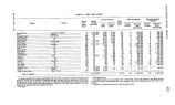
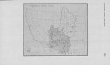
Show BOIS && SIOUX RIVER LITIGATION 523 Having thus pointed out the rules of law which must control our conclusion, we come to consider the much disputed issues of fact upon which our decision as to the injunction prayed turns. The boundary line between South Dakota and North Dakota on the west, and Minnesota on the east, runs through the middle of Lake Traverse and thence north by the channel of the Bois de Sioux River until that river joins the Otter Tail River to make the Red River of the North. Lake Traverse lies in a basin between Minnesota and South. Dakota. The east and west line between the two Dakotas is some five miles north of the point of discharge of the Lake into the Bois de Sioux. The basin is the bed of an ancient lake formed by glacial action. The present lake reaches from southwest to northeast, has an average width of more than two miles and is with its extended ponds and swamps about twenty miles long. To the south it has high rocky banks and is a real lake. As it extends toward the north, it is divided into smaller lakes or ponds or sloughs by deltas from enter- ing streams. The Mustinka River reaches the Lake at its northern end just beyond the region of its high banks and makes a delta walling off Mud Lake. The Bois de Sioux flows north and is a sluggish stream, with low marshy banks for fifteen miles to a point opposite where the Rabbit River enters from the Minnesota side. Beyond that, its banks grow higher. It flows down the eastern side of its basin so that the Minnesota low lands on its bank are of small area. The watershed for Lake Traverse and the Bois de Sioux as far as the mouth of the Rabbit River, but not including the watershed of that river, is 1442 square miles, of which 924 miles are in Minnesota and 518 miles are in the Dakotas. Of the 924 miles of Minnesota watershed, 131 miles drain directly into the lake, and 793 miles drain through the Mustinka. Of these, the drainage from 105 miles enters below the ditches and tributaries which play any part in our problem. It will thus be seen that the drainage into the Lake and the Bois de Sioux from the Mustinka River and the ditches, here under considera- tion, is from a watershed of 688 miles, or something less than fifty per cent, of the whole watershed by the run-off from which the basin of the Bois de Sioux in 1915 and 1916 was overflowed. The Mustinka watershed extends northeast from Lake Traverse across a level prairie country, embracing much of Traverse County and part of Grant County, Minnesota, until it reaches on the east, north and south a much higher level of hills and hollows with lakes and standing pools called in this case the Moraine Zone. The trend of the Mustinka River bed upwards from the Lake is at first to the northeast some twenty odd miles to a point where Twelve Mile Creek enters the river from the south, thence easterly several miles to where Five Mile Creek enters the river also from the south. Above this point, the river is known as the Upper Mustinka. Of these three constituents, Twelve Mile Creek is the dominant stream, draining 364 miles, or 54 per cent, of the whole Mustinka watershed. Five Mile Creek drains 121 square miles, or 16% per cent., while the Upper Mustinka drains 203 square miles, or 29 per cent. The Upper Mustinka is a winding, crooked stream with banks not always well defined, and with a fall in its channel of 2.25 feet to the mile. Five Mile Creek is less crooked but with low banks easily overflowed and a slope of five feet in the |