| OCR Text |
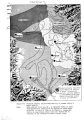
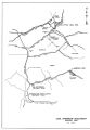
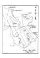
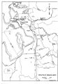
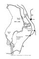
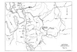
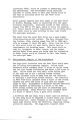
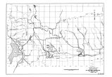
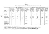
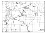
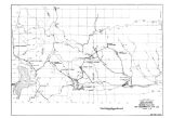
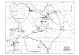
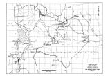
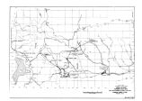
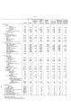
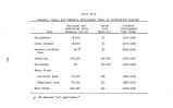
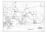
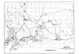
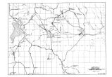
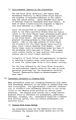
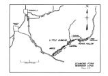
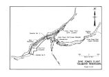
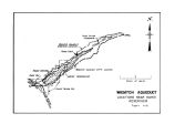
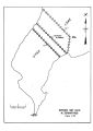
Show Wanship Dam would need to be enlarged. It now stores 62,000 aere- feet of water in Rockport Lake, with a water surface area of 1,020 acres. There are two developed campgrounds on the east side of the lake, one with a boat- launching ramp. These facilities were constructed by the Bureau of Reclamation in 1959. 2_. High- Level Plan Perdue Dam and Reservoir site is located in the Weber River Canyon about 5 miles upstream from Oakley. Pinon pine, juniper ( cedar), and oakbrush cover the damsite and canyon walls of the reservoir area. Mountain valley meadows are on the valley floor throughout the reservoir basin. This area has experienced considerable development in the way of summer homes and cabins. The pipeline from Slaterville Diversion Dam would be the same as for the low- level transfer plan. Provo Reservoir Canal and Jordan Aqueduct would be the same as in the proposed plan. Environmental Impacts of the Alternative 1M Low- Level Plan Excavation for the pipeline from Slaterville Diversion Dam to the Davis- Weber Canal near Hill Air Force Base would disrupt the la. ndscape. If constructed now, mostly farmland would be involved. Likewise, excavation for the aqueduct from Sand Ridge near Hill Air Force Base to Kearns- if constructed now- would involve mostly farmland and orchards. Stretches of salt- grass pastures near the Salt Lake International Airport would be traversed. In the farmland and orchard areas home building is taking place; therefore, the alinement now chosen would probably run through housing developments in a few years. Enlargement of Wanship Dam would inundate 2.2 miles of Class II fishery, two recently constructed campgrounds, and an additional 1,210 acres of land. The two campgrounds would require relocation. The land that would be inundated has oakbrush, pine, willow, cottonwood, spruce, chokecherry, Douglas fir, juniper, box elder, birch ash, Russian olive trees, and brush growing in a wild state, as well as planted within the camp and picnic grounds. 539 |