| OCR Text |
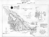
Show -17- more or less, depending upon the point where we may finally decide to recross the Line, which point is arbitrary. You will understand that that portion of the Central canal, lying between the East Branch Fork and Mesquite Lake, is not yet surveyed, and the line, as shown on map A, is subject to very considerable change. It marks however, my present ideas of where the canal will go, and I feel quite sure in stating that it will occupy the present location as marked on the map, unless I find that I can economically shorten it. The country along the route of the Central canal, from the East Branch Fork, to Mesquite Lake, is a smooth plain, unbroken except where the Salton River cuts through it; I have the profile of the Boundary Line from the East Branch canal to Signal Mtn., I have also the exact location and elevation of Mesquite Lake. With this data, which gives me approximately the length of the canal, and exact elevations, I feel that the line, as shown, is not far out of the way and the estimates for that portion between the Fork and Mesquite Lake, as given in this report, are amply safe. The exact surveys, instead of being carried on the Central Route to Mesquite Lake, were carried along the East Branch to Flowing Well; but, in the progress of the East Branch survey, the fact was developed that three main branches, the East, the West and the Central, would be eventually required, and that the Central canal could be constructed for less |
| Source |
Original book: [State of Arizona, complainant v. State of California, Palo Verde Irrigation District, Coachella Valley County Water District, Metropolitan Water District of Southern California, City of Los Angeles, California, City of San Diego, California, and County of San Diego, California, defendants, United States of America, State of Nevada, State of New Mexico, State of Utah, interveners] : California exhibits. |


