| OCR Text |
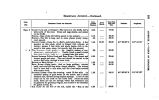
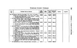
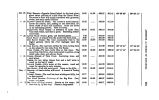
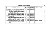
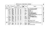
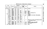
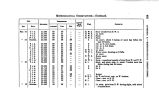
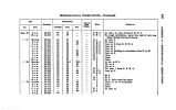
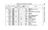
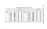
Show HOMEWARD JOURNEY- Continued. to * * 1 O u B DATI. 1850. Sept 20 " 21 " 23 Psoimnare POINTS AHD RULUUES. MUDDY CREEK- Leave this creek one mile below its forks. It rises in the Park Mountains. SUMMIT BETWEEN THE PAOITIO AND ATLANTIC WATERS- Ascent very gentle; pass several small springs. The champagne country continues to the Wind River Mountains, nod oan be crossed in many places, the choice being determined by considerations of fuel and water. SPRING- Noon halt- Aspen grove spring, head of a branch to Sage Creek. The route to the south of this, along the base of Aspen Mountain, would be shorter and better. WEST BRANCH- Leave this branch, and pass over a low swell to the east. MIDDLE BRANCH- Camp No. 20- On right bank of a small stream from the south. Sage abundant; grass rather poor. EVANS' TRACE- Direction from the camp is toward the Medicine- bow Mountains. Evans' Trace from Bitter Creek here crosses Sage Creek valley. SAGE CREEK- From south ; 40 feet wide ; a brisk shallow stream; then ascend and pass over a gullied ridge. NORTH FORK OF THE PLATTE RIYBR- Left bank: a beautiful poplar grove and park; remains of old Indian forts: war-frourii] * A" neighbouring tribes; fine grazing; buffalo herds firo frequently met * ith here. The measured distances to this pujiit IIT « checked by the longitude given by Col. Fremont. PLATTE FORD- The road along the left bank in cotton- wood groves; hills and valley well grassed; ford over a ripple; deepest water at present stage, 2J feet, and banks easy. Thence rise gradually to the plain. Intermediate Distance. 2.27 6.88 2.22 6.23 4.65 1.90 6.47 7.02 2.98 Day's March. 21.75 16.29 Total from Salt Lake City. 812.41 818.79 321.01 827.24 831.89 883.79 840.26 848.18 851.16 Latitude. 41° 88' 22". 8 41° 85' 21" 41° 82' 49". 2 Longitude. 107° 8( K 48" 107° 21' 52" 107° 06' 11" |


