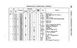
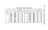
| OCR Text |
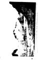
Show 232 SHOSHONEE WARRIORS- RABBIT HOLLOW. charging down upon us at full speed. The pack- mules and loose animals were immediately driven back into the bushes, where they could be more easily defended, while, accompanied by Major Brid-ger, I advanced to the bank of the stream to reconnoitre. We soon ascertained that the party consisted of a band of some twenty Shoshonees, who were out upon a hostile expedition against the Utahs, and that, mistaking, as they said, the smoke of our fires for that of their enemies, they had charged down upon us, in full ex* pectation of effecting a surprise. As soon as they discovered their mistake, they crossed the creek in compliance with our invitation, and greeted us in the most friendly manner. The party was armed in a most heterogeneous way, some having rifles, others old bayonets fastened upon the extremities of long poles, and the rest bearing only bows and arrows, with a little round shield suspended from their necks. They were, for the most part, well- mounted upon small, but apparently excellent horses. There being no longer any occasion for alarm, the animals were driven from their cover, and leaving our red friends to pursue their own course to the southward, we resumed our march, although it had commenced to rain quite heavily, with every prospect of a stormy day. Recrossing Black's Fork, we followed up a small depression, and in about a mile reached by a gentle ascent the summit of a long ridge, stretching eastwardly toward the valley of Green River. Crossing this ridge we struck upon the broad valley of another affluent of Black's Fork, which we pursued for about six miles to its head, when we reached the " divide" between that stream and the waters of Green River. From the " divide" we descended a long and winding ravine, called Rabbit Hollow, / which joins the valley of Green River two miles above the mouth of Bitter Creek, a considerable stream flowing into that river from the eastward. The lower part of Rabbit Hollow will require to be partially worked, to avoid the bends of the dry bed of a stream which winds from side to side of the narrow bottom; but, with this trifling exception, an excellent wagon- road can be traced from Green River at this point to Fort Bridger, and by a very direct route. The north side of this ravine, near its mouth, is flanked by lofty vertical cliffs of indurated green clay and shales, overlaid by horizontal strata of a soft, yellowish sandstone. The same formation occurred on the eastern side of Green River; and the turreted appearance of the crumbling sandstone cliffs, four hundred feet in height, was in a high degree imposing and picturesque. |