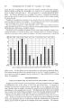
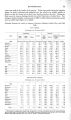
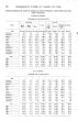
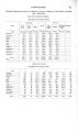
| OCR Text |
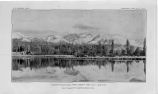
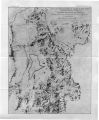
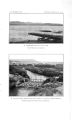
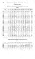
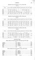
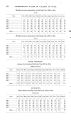
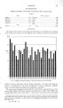
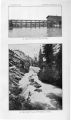
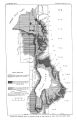
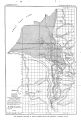
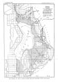
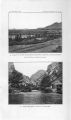
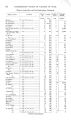
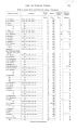
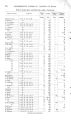
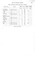
Show - INDEX. A. Page. Alpine, water supply of 49 American Fork ( town), water supply of, source of 49 wells in 49- 50 American F o r k ( s t r e a m ) , description o f . . . . 6,49 discharge and run- off of, t a b l e showing. 21 view of 50 water from, analysis of 30 use of. 49 American Smelting and Refining Company, well of, record of 46 wells of, water from, analysis of 32 Analyses of w a t e r from various s t r e a m s and springs 30,32 Artesian wells. See Wells, flowing. B. B a t t l e Creek, description of 6 drainage of, effect of, on wells 51 water of, use of 49 Bear River, description of 6 Beck's h o t spring, water from, analysis of.. 30 Bed rock, water f r o m . . . 50,53 water from, methods of o b t a i n i n g 37,40 Benjamin, underground w a t e r conditions a t . 54 Big Cottonwood Creek, description of 7,45 discharge and run- off of, t a b l e showing. 21,25 rocks on 9 water from, analysis of 30 use of 44,45 Big Cottonwood Creek Valley, seepage measurements in 28 Big Hollow Creek, description of 53 Bingham, mines a t , water in 37,40 rocks n e a r 10 water supply of, source of 40 Bingham Canyon, placer mining in 40 Bingham Consolidated Company, wells of.. 37 Bingham Creek, description of 39 Bingham Junction, smelters a t 5 wells a t , water from, analyses of 32 Bonneville region, Pleistocene h i s t o r y of... 12- 13 Bonneville shore line, description of 12- 13 Bonneville terrace, description of 47 Boutwell, J. M., on discharge of Ontario tunnel 37 on P a r k City and Bingham mining dist r i c ts C Page. Cambrian fossils, occurrence of io Cambrian rocks, occurrence of 9,10,11 Cameron, F. K., analyses of water b y 30 Cannon farm, well on 41 Capitol Hill, reservoir on 45 Carboniferous rocks, occurrence and character of 9,10,11 City canal, discharge of 24 City Creek, description of 7 discharge and run- off of, t a b l e showing. 19 rocks on 8 water from, analysis of 30 use of 44,45 Clarke, F . W., analysis of water by 30,33 Climate, character of 13- 18 Colorado Fish Company, well of, descript i o n of '. 51 Comer, H. C , on general section in vicinity of Lehi 48 Converse, W. A., analyses of water by 32 Cooper, William, well of, water from, analysis of 32 Cottonwood Canyon, view in 24 Cox, A., well of 53 Currant Creek, description of 6 reservoir on, failure of 55 rocks on 11 water from, analysis of 30 use of 55 D. Dalton and Lark tunnel, description of 40 water in, occurrence of 37 Dams, subsurface, recovery of underground water by 37 De Bernard, J. H., analyses of w a t e r b y . . . . 32 Dead Mans Falls, Cottonwood Canyon, p l a t e showing 24 Dearborn laboratories, analyses of w a t e r b y . 32 Decker Lake, d i t ch a t outlet of, discharge of. 25 Devonian rocks, occurrence of 8,9,11 Doremus, A. F., spring discharge measured by 44 Drainage, character of 5- 7 Drainage area discussed, map showing 6 Draper, warm- water lakes near, description of 47 Dry Cottonwood Creek, description of 7 water from, analysis of 30 Dry Creek, description of 6,48 Dry Creek Canyon, springs in 49 Du Chesne River, source of 6 24 6 11 25 on well drilled for oil 41 Brown, R. E., analyses of water by 30 Bureau of Soils, Department of Agriculture, . experiments in reclaiming land near Salt Lake City made b y 43 Butterfield Canyon, springs in 40 t u n n e l s d r i v e n for water in 37 Butterfield Creek, description of 39 Butterfield tunnel, water in, litigation c a u s e d b y 40 43 E. East J o r d a n canal, discharge of East Tintic Mountains, location a n d eleva- tion of s t r u c t u r e of Eighth South s t r e e t ditch, discharge of 77^ |