| OCR Text |
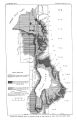
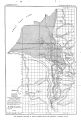
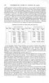
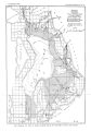
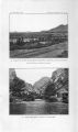
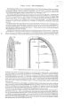
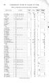
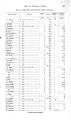
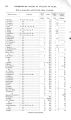
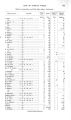
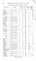
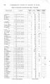
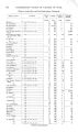
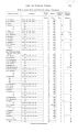
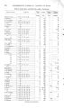
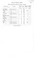
Show 8 UNDERGROUND WATER IN VALLEYS OF UTAH. reported on the Mercur mines, and, more recently, work has been carried on in the Park City and Bingham mining districts by J. M. Boutwell. o The following sketch is mainly compiled from these reports. DESCRIPTIVE GEOLOGY OF THE HIGHLANDS. The Wasatch Mountains are composed of a complex mass of sedimentary, igneous, and metamorphic rocks that have been much folded and faulted. In age the rocks range from pre- Cambrian to Tertiary and constitute a thickness of about 50,000 feet. The following table shows in epitome the main Paleozoic divisions according to the Fortieth Parallel Survey: Paleozoic section in the Wasatch Mountains. System. Formation. Average thickness. Feet. 2,500 t o 3,000 5,000 t o 7,000 7,000 1,000 t o 1,250 1,000 t o 1,250 12,000 30,000 The present mountains are the eastern part of a greater mass of rocks, the Wasatch Range having been raised by faulting several thousand feet higher than the western part of this mass, which now lies buried beneath the valley deposits. This great fault is the dominant structural feature of the region. The range rises abruptly 7,000 feet above the wide lowland at its base, where the streams, which in their mountain courses occupy deep-cut narrow gorges, flow in wide valleys. The fault cuts across the range regardless of the structure of the rocks, and the truncated mountain bases abut against the plain in marked alignment. Beginning at the north and proceeding southward the following features may be noted: The spur that juts out from the Wasatch Mountains north of Salt Lake City marks the southern boundary of a series of pre- Cambrian rocks that constitute the crest and western flanks of the mountains to the northwest, almost as far as Ogden. These rocks for the most part consist of gneisses and mica- schists, considered to be of sedimentary origin, with which are associated quartzites, slates, and some igneous rocks. In general the strike is N. 20° W., and the prevailing dip is westerly at angles ranging from 15° to 20°. A great thickness of coarse Tertiary conglomerate lies high up on the northeastern flanks of the range, but at the southeastern end of the crystalline area Paleozoic sediments abut against the older series and dip southeastward. An outlying mass of nearly horizontal coarse Tertiary conglomerate, composed chiefly of pebbles of limestone and quartzite, caps the spur of the mountains north of Salt Lake City and conceals the older sediments except along the western base of the spur, where the Wasatch limestone outcrops. A small isolated body of volcanic rock outcrops in the midst of the Tertiary area and is bisected by City Creek. The headwaters and upper course of City Creek lie in Paleozoic rocks, chiefly in the Weber quartzite and Wasatch limestone, which dip southeastward at angles varying from 30° to 65°. Across the divide a large area of flat- lying Tertiary rocks cap the disturbed Paleozoic series. oBoutwell, J. M. Progress reports Park City mining district: Bull. U. S. Geol. Survey No. 213,1903, pp. 31- 40; No. 225, 1904, pp. 141- 150; No. 260, 1905, pp. 150- 153. Economic geology Bingham mining district: Prof. Paper U. S. Geol. Survey No. 38, 1905 ( with a section on areal geology by Arthur Keith and an introduction on general geology by S. F. Emmons). |