| OCR Text |
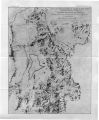
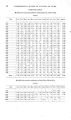
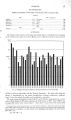
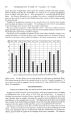
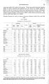
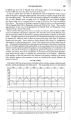
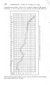
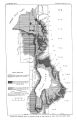
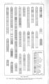
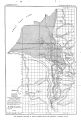
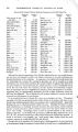
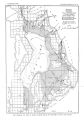
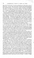
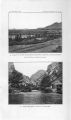
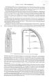
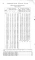
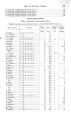
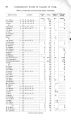
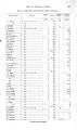
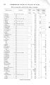
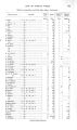
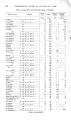
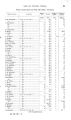
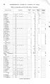
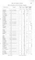
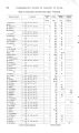
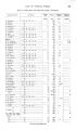
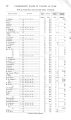
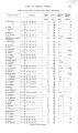
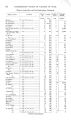
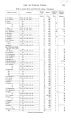
Show SOURCE AND DISTRIBUTION. 29 of measurements which should be made in estimating the feasibility of constructing subsurface dams. The amount of water contributed to the valleys from bed- rock sources is also important. A remarkable series of thermal springs is associated with the great fault at the western base of the Wasatch Mountains. These occur at intervals along the entire extent of the range, and other warm springs, which may also be connected with faults, are located within the area under consideration. Association with faults suggests a deep-seated origin, which accounts for the high temperature of the water. The last source of the valley water supply to be mentioned is the comparatively small amount which is derived by seepage from the base of the mountains from areas that are not drained by creeks. DISTRIBUTION OF UNDERGROUND WATER. From the outline of the geology given on pages 7- 13 it will be seen that the valleys of Utah Lake and Jordan River are occupied by a considerable but unknown thickness of gravel, sand, and clay derived from the disintegration of the adjacent mountains and deposited in the valley under alternating subaerial and lacustrine conditions. In general, the deposits are arranged in broad, sheet- like accumulations, the coarser- textured materials abounding adjacent to the highlands and the finer debris preponderating farther out. The beds lie practically flat in the center of the basins, but are inclined slightly away from their source, the attitude of deposition being practically unaltered. Conditions of deposition, however, were so varied that over large parts of the area considered the deposits are not widely uniform. For instance, while clay was being laid down in one place sand was accumulating in an adjacent area and at their border the two deposits were merged. Consequently the arrangement of the beds is broadly lenticular, as is illustrated by the well records ( PI. V). No two records are exactly alike, and in most cases it is impossible to correlate deposits in the different sections. Beds of clay are most widely distributed, but the more localized accumulations of sand and gravel, which are the most important reservoirs of underground water, are irregularby distributed. Underground water derived from the sources stated above occupies the spaces between the solid particles of the clay, sand, and gravel which constitute the valley filling. In general, these deposits are saturated below the horizon which marks the surface of ground water. The position of this surface varies, depending on the supply, on the amount used or the intensity of evaporation, and on the character and slope of the sediments. The water is seldom stagnant, but tends to flow with extreme slowness from a higher to a lower level, the chief factors in the movement being the number and size of the interstitial spaces in the deposits and the pressure gradient due to gravity. The highest velocity of ground water ever determined is about 100 feet in twenty- four hours, but the ordinary velocity is much less than this, common rates in sand being between 2 and 50 feet a day. The fluctuation of the surface of ground water is considerable. Since the chief replenishment of the supply occurs when the creeks discharge the most and when the irrigation canals are in full operation, ground water occurs nearer the surface in summer than in winter. Conditions in different areas cause a varied annual range, but 10 feet is common and 15 feet is not infrequent. In addition to the annual fluctuation a cumulative change is in progress, the ground- water surface being gradually raised in the lower parts of the valley in consequence of irrigation and the custom of allowing artesian wells to flow unceasingly, leading to swampy conditions in the valley bottom. Details regarding these changes are given on subsequent pages. PI. VI illustrates the approximate average depths at which ground water occurs in the valleys of Utah Lake and Jordan River. The boundaries between the different areas fluctuate and can not accurately be determined. A narrow belt contiguous to the base of the mountains is left blank on the map because of the varying and often unknown conditions that exist there, owing to seepage and the irregular distribution of water in the adjacent bed rocks. In the absence of topographic maps the position of the water table can not be shown by contours. Below the surface of ground water the saturated beds contain varying amounts, depending on the character of the deposits. Coarse- textured gravel and sand, having a greater porosity than fine- textured clay, hold and transmit relatively more water. Beds of sand and gravel therefore constitute the chief underground reservoirs. Typical illustrations of the distribution of sand and gravel are shown in PI. V. In sinking wells in this region, beds |