| OCR Text |
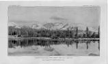
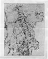
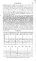
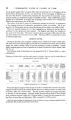
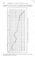
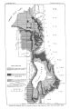
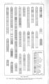
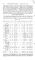
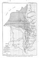
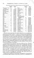
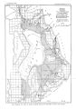
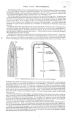
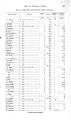
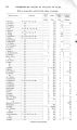
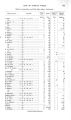
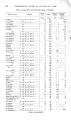
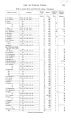
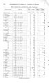
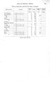
Show OCCURRENCE OF UNDERGROUND WATER. 55 Flowing wells have been obtained throughout this area at depths of 50 to 500 feet, as shown by the list. Flows are usually found in every considerable bed of sand encountered in drilling, and six or more water- bearing beds are sometimes struck in a 400- foot well. Shallow wells are not the rule in this region, for, though many are 150 to 200 feet deep, the majority are nearer 400 feet deep. Because of the general absence of gravel and of persistent beds of sand there are few especially good wells. The flows obtained are generally under 50 gallons a minute and frequently are less than 10. The pressure is low, seldom being sufficient to cause the water to rise more than a few feet above the surface. At the southern end of the lake, north of West Mountain, just above low- water level there is a warm spring that was estimated to flow 200 gallons a minute. Its temperature is 88°. GOSHEN VALLEY. Goshen Valley can be divided into a highland and a lowland portion, a convenient line of division for present purposes being that which separates areas where ground water lies above 10 feet from the surface, from those in wThich it lies below that depth. The highland lies contiguous to the mountains and merges into the lowland which adjoins the lower course of Currant Creek and the southern extremity of Utah Lake. The lowland is chiefly underlain by clay and the soils contain abundant alkali. a Throughout the entire area ground water lies close to the surface and marshy conditions exist, especially toward the lake. The area of flowing wells in Goshen Valley embraces about 15 square miles and extends from Utah Lake to within about a mile of Goshen. Within it flowing wells are obtained at depths ranging from 50 to 400 feet. From the few available records it appears that varying stratigraphic conditions exist in this area, the prevailing clay being irregularly interbedded with sand, usually in thin streaks, with very little gravel. The flows obtained are small, averaging possibly about 5 gallons a minute, and the pressure is sufficient to cause the water to rise only a few feet above the surface. Goshen itself is furnished with surface water from ditches supplied by Currant Creek and by springs located at the base of the hills about 2 miles east of the town. The underground supply is derived from wells that usually range from 25 to 75 feet in depth. The wells are put down through clay to sand in which water is found under pressure sufficient to cause it to rise almost to the surface, the usual depth to wrater being 3 to 20 feet. A number of unsuccessful attempts to get flowing wells have been made, the deepest being the railroad well put down near the station. It is 334 feet deep, and water is reported to have risen in it to within a few feet of the surface. The highland area is underlain chiefly by coarse detritus derived from the adjacent mountains and distributed either as shore deposits in Lake Bonneville or as alluvial accumulations. This higher portion of Goshen Valley is poorly supplied with water, the chief sources being Kimball Creek, a small stream which seldom flows below its mountain course, and Currant Creek, which flows perennially and supplies the lower valley. The discharge of Currant Creek, however, is insufficient for the needs of the upland. A reservoir has been built by damming Currant Creek at the entrance to its canyon course through Long Ridge, and a canal constructed which skirts the upper part of Goshen Valley, but the enterprise has been a failure. A few springs occur along the eastern base of the Tintic Mountains and some successful attempts have been made there to develop underground water by tunneling. In the upper valley of Kimball Creek there are a number of springs which flow about 100 gallons a minute, and smaller ones occur in several gulches. About 2 miles east of Goshen there is a group of springs at the base of Long Ridge, where water issues through debris and accumulates in several small ponds, the temperature of which is reported to stay at about 70° F. throughout the year. These springs constitute the source of Warm Creek, and their combined flow in November, 1904, was estimated at about 5 second- feet. Water has been developed a Sanchez, A. M., Soil survey of the Provo area, Utah: Bull. Bureau of Soils, U. S. Dept. Agric, 1904. |