| OCR Text |
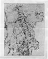
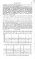
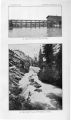
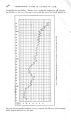
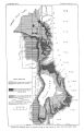
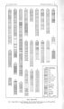
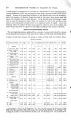
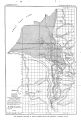
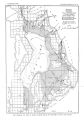
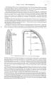
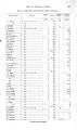
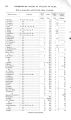
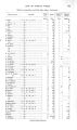
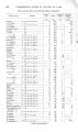
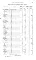
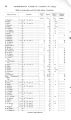
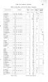
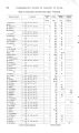
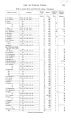
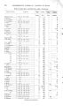
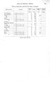
Show 5 2 UNDERGROUND WATER IN VALLEYS OF UTAH. The beds about Provo appear to dip toward the lake at a low angle, approximated corresponding to the slope of the surface, this being indicated by the fact that the depth at which the water- bearing gravel is found over large areas is approximately constant. In the vicinity of Provo some direct data were obtained on this point. Wells have been driven along Center street from Academy street in Provo westward to the shore of the lake. The depths at which the top of the gravel was struck in some of these wells was obtained from the driver, J. Westfall, and a line of levels was run along the surface by the United States Reclamation Service, from which it appears that the lakeward inclination of the gravel is approximately 9 feet per mile, the rate decreasing as the lake is approached. Similar conditions probably exist throughout the area studied, the slope being greatest near the mountains, while beneath the broad lowlands the strata lie more nearly horizontal. Ground water in the vicinity of Provo can generally be obtained in the upper gravel within 10 feet of the surface. In the vicinity of the lake the gravel disappears and clay generally occupies the surface. Here, as is so general throughout the entire area, swampy conditions prevail, owing to the lowness of the region, the recession of the lake, and the rise of ground water due to irrigation. Flowing wells exist in great number in this well- populated region, and in general an abundance of good water is obtained within 200 feet of the surface. The main water- bearing horizon is the bed of gravel that underlies the blue clay. Water is generally reached in this gravel at 150 to 200 feet from the surface, but conditions are not absolutely uniform at all places, and where the prevailing section is varied by local streaks of clay, sand, and gravel corresponding differences exist. Feeble flows are sometimes found at 100 feet, and a few wells obtain water from a depth of 360 feet, but this depth is unusual in the vicinity of Provo. The wells about Provo are generally 2 inches in diameter, and their flow may possibly average 50 gallons a minute. Among the best wells in this vicinity are those at the stations of the San Pedro, Los Angeles and Salt Lake Railroad and the Rio Grande Western Railway. These are 3 inches in diameter and 190 and 176 feet deep, respectively. In November, 1904, the Rio Grande Western well was found to flow approximately- 120 gallons a minute at 2 feet above the surface under a pressure of 15J pounds per square inch. SPRINGVILLE AND VICINITY. Between Provo and Springville the lowland contiguous to Utah Lake extends to the Rio Grande Railroad, above which the surface rises at a steep grade to the base of the mountains. The lowland for the most part is marshy, and the line that separates flowing and nonflowing wells lies only a short distance east of the railroad. A low scarp, which apparently marks a Pleistocene fault, can be traced immediately wTest of the county road for a mile or more beyond the Utah County Infirmary toward Springville. Springs occur at the base of the scarp, and the large springs at the head of Spring Creek may be associated with faulting. A number of small lakes mark the presence of these springs, and Spring Creek, whose main supply is thus derived, flows about 1,600 second- feet. The deepest well in this area is that of the infirmary, situated near the road about midway between Provo and Springville. The well is 3 inches in diameter and 270 feet deep, and water is reported to rise in a pipe to a point 3 feet above the surface, flowing about 30 gallons a minute. In this vicinity a feeble first flow is reported at depths of 65 to 80 feet. Springville is situated on the plain about 3 miles below the mouth of Hobble Creek Canyon, the channel of the creek passing through the town. During the irrigation season practically all of Hobble Creek water is diverted by canals that head near the base of the mountains. / Ground water in Springville is obtained from wells that usually range in depth from 20 to 30 feet, the water occurring in the top gravel. The general level of ground water in the town is reported not to have changed since the early days, and only an annual difference of a few feet is noticed between winter and summer conditions.^ a Stevenson, J. B., well driver. |