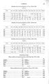
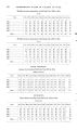
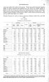
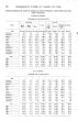
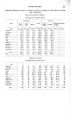
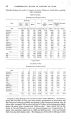
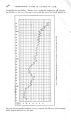
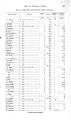
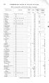
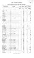
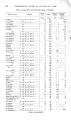
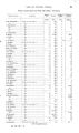
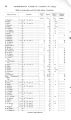
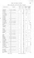
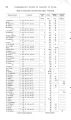
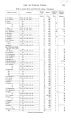
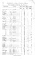
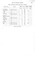
| OCR Text |
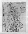
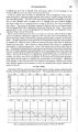
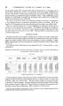
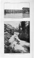
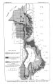
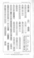
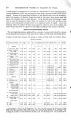
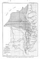
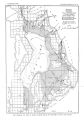
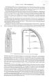
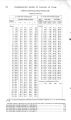
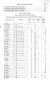
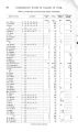
Show 4 0 UlSTDEBGllOUND WATER IlST VALLEYS OP UTAH. penetrates downward until a relatively impervious layer is reached, when it tends to spread laterally and to slowly move toward a lower level, at the same time rilling, to a greater or less extent, the voids in the overlying material. In the greater part of the area occupied by Lake Bonneville bed rock is so deeply covered by valley deposits that it is impracticable to recover the water contained in it; but along the border of the old lake, where the rock outcrops, water is obtained from tunnels in a number of places. In the development of the Bingham mines more or less water has been encountered, and the town is supplied from mine tunnels. Water has also been found in two tunnels constructed for mining purposes near the base of the mountains. The Butter-field tunnel, in Butterfield Canyon, a few miles west of Herriman, encountered considerable water, which has caused some litigation. After the construction of the tunnel a number of springs tributary to Butterfield Creek ceased to flow, and suit was brought against the mining company by the inhabitants of Herriman. Apparently the source of the springs was tapped by the tunnel, and judgment was awarded against the mining company. The Dalton and Lark tunnel, west of the town of Lark, struck water in the spring of 1903. The tunnel was driven 5,000 feet through igneous rock before the water was found. It occurs in quartzite that is reported to be much broken and fissured. The supply was estimated at first to be 2,500 gallons a minute, but in the summer of 1904 this had decreased to about 1,500 gallons, most of which was used for irrigation at a ranch about 2 miles east of the mouth of the tunnel. The quantity is reported to be greatest shortly after the time of melting snow, thus indicating the source. The experience of these tunnels indicates in general what may be expected by driving into the Oquirrh Range. Springs of greater or less magnitude occur in a number of places along the base of the mountains. These are either supplied by seepage or b}^ water from a deeper- seated source. In Rose, Butterfield, and Bingham canyons a number of springs occur, which help maintain the flow of the streams. Also at irregular intervals along the border of the upland there are springs which, in general, supply only a few gallons a minute. A conspicuous locality is in the northwestern part of T. 2 N., R. 2 W., where a local area of shallow ground water occurs. Along the northern base of the Oquirrh Range there is a group of large springs, which occur in notable alignment and apparently are associated with a fault. The water issues from unconsolidated debris and is slightly warm and brackish. The springs have an elevation of only a few feet above the lake, however, and are too low to be of much service without pumping. Analysis of one, known as the Jap Pond, shows a content of 114 grains per gallon of dissolved salts, chiefly sodium chloride. The total discharge of 9 of these springs in April, 1905, amounted to 8.5 second- feet, and it is reported that the flow remains practically constant throughout the year. On the upland, between the base of the mountains and the canals, the little underground water that is recovered is obtained from wells, but in this entire region, with very few exceptions, ground water lies over 50 feet beneath the surface. A few wells have been sunk on the upland away from the lines of surface drainage, and in general they have been failures. The most successful wells are along the courses of creeks and arroyos, and future search may be carried on with the best prospect by following these drainage ways where the water tends to accumulate. Development in Bingham Canyon illustrates the occurrence of underground water beneath a surface- drainage way. More or less placer mining has been carried on in the creek gravels, but near the mouth of the canyon, where there is a considerable amount of debris, work has been seriously interrupted by the abundance of water beneath the bed of the creek. It is in such places, where rock walls confine a narrow channel, that tests might well be made with the view of constructing subsurface dams to impound the underflow. Below the canals ground water lies nearer the surface, because of the lower elevation of the country and the increased supply derived by seepage from the canals. Ground water lies at a greater depth than 50 feet only in a narrow belt below the Utah and Salt Lake Canal, and in most of the area between the canals and the line of flowing wells ground water |