| OCR Text |
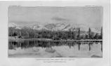
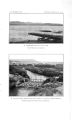
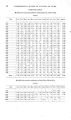
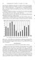
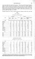
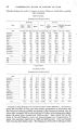
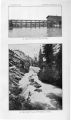
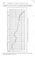
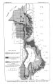
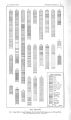
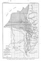
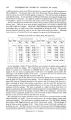
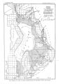
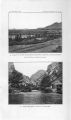
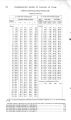
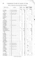
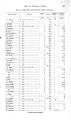
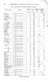
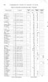
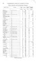
Show 4 4 UNDERGROUND WATER IN VALLEYS OF UTAH. at different horizons from about 50 feet downward, a common depth of wells being between 100 and 300 feet. The deepest well is that of the Rio Grande Western Railway Company near its station, the record of which appears on page 42. This well is 4 inches in diameter and 1,073 feet deep. It was put down in 1895 and 15 horizons were passed through from which flows were obtained. At a depth of 1,048 feet the greatest flow occurred, amounting to 78 gallons a minute at 4 feet above the surface and to 37.5 gallons at 25 feet above. The most notable group of wells in this vicinity is that put down by Salt Lake City adjoining Liberty Park. There are 16 or more of these ranging from 2 to 9 inches in diameter and from 100 to 600 feet in depth. About half a dozen different water- bearing horizons, each furnishing a flow, are said to have been encountered in driving the wells. The greatest pressure reported caused the water to rise in a pipe 35 feet above the surface. Discharge measurements, as furnished by the city engineer, are given in the following table: Discharge of city wells near Liberty Park, Salt Lake City. No. of well. 1 . . . . 2 . . . . 3 . . . . 4 . . . . 5 . . . . 6 . . . . 7 . . . . 8 . . . . 9 . . . . Diameter. Date of measurement. No. of well. Diameter. D a t e of measurement. Aug. 10, 1890. J u l y 17, 1900. Sept. 29, 1902. Aug. 10, 1890. J u l y 17, 1900. Sept. 29, 1902. Inches. 9 9 8 8 8 2 2 2 2 Gallons. 201,600 180,000 279,132 Gallons. 120,000 297,000 280,000 215,000 5.000 Gallons. 96,941 60,588 302,940 193,882 11,459 5,876 610 206 19,784 10 1 1 . . . . 12 1 3 . . . . 1 4 . . . . 1 5 . . . . 1 6 . . . . Inches. 2 2 2 2 2 9 2 Gallons. 43,200 33,230 36,000 54,000 Gallons. 38,000 „ 19,000 16,000 35,000 18,000 98,000 6,000 Gallons. 35,644 15,892 14,213 20,626 13,316 36,172 2,844 59,040 14,400 10.000 16,000 27,000 54,000 1,000 500 25,000 997,602 1,183,500 830,993 In the immediate vicinity of these wells there are a number of springs whose supply is maintained chiefly by seepage. The combined flow from these, springs and wells is estimated to amount to a maximum of 2,500,000 ' gallons a day. In order to utilize this supply in the city mains a pumping plant would have to be installed, and a further disadvantage is the doubtful quality of the water. At present this source is used for street sprinkling and for feeding the lake in Liberty Park ( PI. I). In the northern part of Salt Lake City several thermal springs occur, the most conspicuous of which are the hot and warm springs. The hot springs issue at a temperature of about 130° from the Wasatch limestone at the western end of the spur of the mountains, with a discharge of about three- fourths second- foot, a and flow into Hot Springs Lake. The warm springs issue from unconsolidated deposits at the base of the spur about 2 mi. es southeast of the hot springs. The water is pumped to a slight elevation, from which it Is piped to a sanitarium, the amount delivered being reported to average 350 gallons a minute. The temperature is 118° at the springs and about 100° at the sanitarium. Several other similar, but less important, springs occur, associated with the great WTasatch fault, along the base of the mountains between hot and warm springs. The municipal water supply of Salt Lake City is derived from mountain streams and distributed through city mains. From this source there is an excellent supply of pure water under good pressure. The chief near- by available streams are City, Red Butte, Emigration, Parleys, Mill, Big » Cottonwood, and Little Cottonwood creeks. The discharges of some of these are given on pages 19- 22. None of these except City Creek is entirely controlled by the city. Red Butte Creek is reserved for the army post at Fort Douglas, Emigration and Parleys creeks partly contribute to the city supply, and the others are used entirely for a Measured by A. F. Doremus. |