| OCR Text |
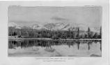
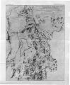
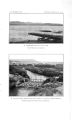
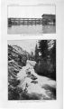
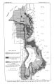
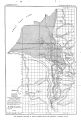
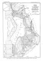
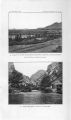
Show OCCURRENCE OF UNDERGROUND WATER. 49 During the irrigation season, when the field wells are all flowing, those in Lehi practically stop, but during the winter it is a general custom to plug the wells used for irrigation, after which those in town begin to flow. Measurements have not been made, but the general facts are well established. Northwest of Lehi the line separating the areas of flowing and nonflowing wells continues to Jordan River, reaching it 3 to 4 miles north of Utah Lake. The line extends about half a mile west of the river and approaches close to the northwest corner of the lake near Saratoga Springs. In the flood plain of Jordan River flows can probably be obtained continuing into Salt Lake Valley, but outside of the line indicated the surface elevation is too great. The Salt Lake City authorities, about 1890, sank a number of wells in the flood plain of Jordan River in sec. 12, T. 5 S., R. 1 W., with the object of increasing the supply of the Jordan and Salt Lake Canal. These wells, about 130 in number, were mostly 2 inches in diameter, though a few were 6 inches, and are said to average 100 feet deep. Clay was encountered down to the bottom of the wells, which were in gravel. It is stated that water rose in pipes 30 to 40 feet above the surface, and that individual wells flowed 125 gallons a minute. It is also stated that the combined flow amounted to 3,000,000 gallons a day. These wells soon interfered with neighboring ones, stopping their flow, and suit was brought against the city, with the result that the municipality was compelled to plug up its wells. After these had been plugged for some time a number of them were temporarily opened, and in about twenty- four hours thereafter the water in one of the wells, the flow of which was interfered with, situated about half a mile above the city wells, had fallen 2J feet. The city wells were then capped again and in five hours the water in the well referred to had regained 7 inches of its lost level. Near the northwestern end of Utah Lake there is a group of hot springs which occur both on shore and in the lake. On the shore there are several springs which support the Saratoga resort where the wrater, having a temperature of 111°, issues through the lake deposits and is used for bathing and to a limited extent for irrigation. In the summer of 1904, during the survey of Utah Lake by G. L. Swendsen of the Reclamation Service, three groups of springs were found beneath the water of the lake. Their existence was shown by the presence of depressions occupying areas of 100 square feet to 3 acres in extent and having depths of 20 to 80 feet. Since the prevailing depth of the lake is much less and the bottom is composed of slimy mud, a considerable discharge is thus indicated. Hot water that flowed above the lake surface was obtained by sinking pipes a short distance into the bottom. About 5 miles up Dry Creek from Lehi is the town of Alpine, located near the mouth of the canyon on the dissected Bonneville terrace. The settlement is supplied with water from irrigation ditches, and possibly not more than half a dozen wells have been sunk. These are 25 to 80 feet deep, and the water level is reported to vary considerably between winter and summer. Springs occur in Dry Creek Canyon, but they have not been developed. AMERICAN FORK, PLEASANT GROVE, AND VICINITY. The towns of American Fork and Pleasant Grove receive their main water supplies, respectively, from American Fork and from Battle and Grove creeks. These streams feed a number of irrigation canals, and are the chief source of underground water in this vicinity. ( PI. IX, B.) American Fork is built at the base of a series of terraces on both sides of American Fork ( creek), which has cut a narrow channel through the old lake deposits. Ascending the valley from American Fork, five distinct terraces can be traced up to the broad Provo bench, between which and the Bonneville level, which forms a shelving bench against the mountains, traces of shore lines of pre- BonneviUe age have been reported. In its lower course American Fork is dry throughout most of the year in consequence of the draft upon its waters for the canal system which supplies the uplands. Shallow wells in American Fork are commonly less than 50 feet in depth, averaging possibly 25 to 30 feet, and the ground- water level is reported to vary 10 to 15 feet between the winter minimum and summer maximum. The water generally is found in gravel. IRR 157- 06 4 |