| OCR Text |
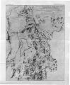
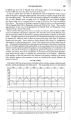
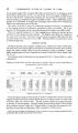
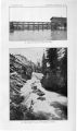
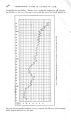
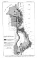
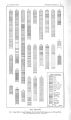
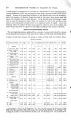
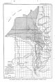
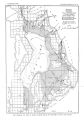
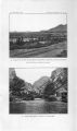
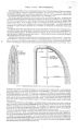
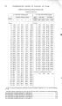
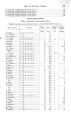
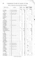
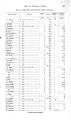
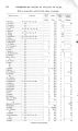
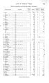
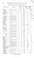
Show 4 8 UNDERGROUND WATEE IN VALLEYS OF UTAH. subsurface dams or by tunnels, mentioned on page 40. Other favorable localities for prospecting are adjacent to the base of the mountains, where water may be had by developing springs and by tunneling into the bed rock. Seep springs occur at several localities along the base of the mountains south of Salt Lake City, the most important, perhaps, being those about midway between Mill and Big Cottonwood canyons. The feeble springs there issuing from sand and gravel were formerly allowed to go to waste, but by developing them a flow of about 2 second- feet was obtained, and a considerable tract of land thus became available for agriculture. About 4 miles southwest of the town of Draper, in sec. 12, T. 4 S., R. 1 W., at some distance from the base of the mountains, there are four warm- water lakes that are fed by springs, some of which are said to be quite hot. The westernmost of the group is the largest and covers an area of about 5 acres. The temperature is reported to remain at about 70° the year round. Since underground water is so scarce beneath the upland, the most efficient manner of developing this area appears to be by the use, as suggested above ( p. 38), of creek water in high- level canals to a greater extent than is now practiced. UTAH LAKE VALLEY. The following description of the occurrence of underground water in the valley of Utah Lake begins at the north and proceeds east, south, and west around the lake, the several towns affording subheadings for convenient reference. ( PI. VIII.) LEHI AND VICINITY. Lehi is situated in the main valley at some distance from the distinct terraces. Dry Creek lies adjacent to the town, but, as its name signifies, the creek, after supplying a number of irrigation ditches, usually carries little or no water in its lower course. There is no public water system in the town, and the supply for domestic purposes is derived from numerous wells. A few shallow dug wells tap ground water at depths of 5 to 30 feet, but the majority are deeper and reach water under pressure. The sugar- plant mill pond is fed by springs and is an important local source of supply. Lehi was one of the first towns where artesian water was found in the Bonneville area, flowing wells having been obtaine* d there about 1880. Formerly a feeble first flow was found in gravel about 60 feet from the surface and a stronger supply at a depth of about 160 feet, but in recent years flows, even from the second horizon, have failed during part of the season in consequence of the increased use of artesian wells in the area nearer the lake, and at times pumping has to be resorted to. However, when water does not actually flow it rises in the wells to within a few feet of the surface. The general section in the vicinity of Lehi, as reported by H. C. Comer, shows blue clay to a depth of 50 or 60 feet. Below this is the first water bed, consisting of about 50 feet of sand and gravel, separated from the second water horizon by 40 feet of light clay. This section does not apply in the eastern part of the town, where the log of the San Pedro Railroad well shows coarse- textur « d material within 100 feet of the surface. In this well tSie main supply is derived from a depth of 330 feet, the water rising to within a few feet of the surface. These two logs illustrate the variability of adjacent sections. The Utah Sugar Company's plant at Lehi has several 2- inch wells, and the following flows in gallons per minute are reported: 80 feet, 15 gallons; 120 feet, 25 gallons; 150 feet, 20 gallons. Logs of these wells were not kept. The Rio Grande Western Railway well near the sugar factory is 3 inches in diameter and 165 feet deep. The water is reported to rise in a pipe to a point 30 feet above the surface and to flow about 50 gallons a minute at the level of the ground. Toward Utah Lake, below Lehi, there is a considerable development of flowing wells from which a number of square miles are irrigated. In this district there are several hundred flowing wells which average about 150 feet in depth. A close relationship has been established between the flow of the wells in the fields below Lehi and those in town. |