| OCR Text |
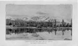
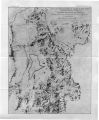
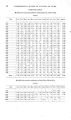
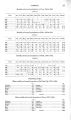
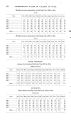
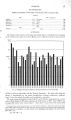
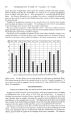
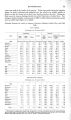
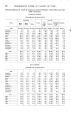
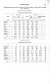
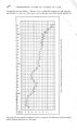
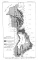
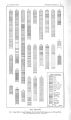
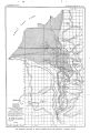
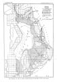
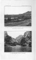
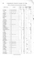
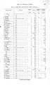
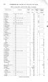
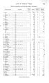
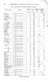
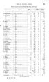
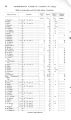
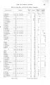
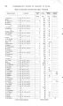
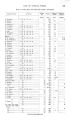
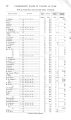
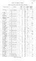
Show 2 8 UNDERGROUND WATER IN VALLEYS OF UTAH. over the valley by canals. Seepage from these streams is the main source of underground supply in the valleys. The amount of water contributed to the valleys by streams from the Wasatch Mountains is capable of rough numerical statement. The drainage area in these mountains tributary to Jordan Valley is approximately 220 square miles, and measurements of five creeks in that region, given in the section devoted to hydrography, show an average flow of 0.66 second-, foot per square mile of watershed. This amount is equivalent to a stream discharging 145 second- feet, or a total amount approximating 105,000 acre- feet a year. The average of measurements of Provo River and Spanish Fork in Utah Lake Valley gives a flow of 0.43 second- foot per square mile of drainage area, which, assuming the flow to be derived from rainfall on a watershed of about 1,670 square miles, is equivalent to a stream discharging 718 second- feet, amounting to 520,000 acre- feet a year. Of this amount of water annually contributed by streams to the valleys of Utah Lake and Jordan River, part permanently runs off and is added to the supply of Great Salt Lake by Jordan River. This quantity has not yet been systematically measured, but it is estimated to average about 200 second- feet. The residue either evaporates, directly and indirectly, or becomes underground water. Unfortunately, no figures are available whereby the amount lost by evaporation can be estimated, so that the annual replenishment of the underground supply is unknown. Only the crude statement can now be made that, in the presence of influences sufficient to cause an evaporation of 60 inches a year from a free body of water, the amount which is not thus lost from a supply of somewhat more than 600 second- feet joins the underground store. Seepage measurements which have been made at different times in both valleys from creeks and ditches offer concrete demonstrations of the manner in which the underground supply is maintained. Only a few such measurements have been made in Utah Lake Valley, but it has been shown that in 1J miles the Timpanogas canal lost slightly more than 25 per cent of the water taken in at its head. a Another set of measurements has been made on Provo River. The discharge a short distance above the mouth of the canyon was found to be 175.04 second- feet; at a station a mile west of Provo the river was dry, while the sum of several intermediate diversions amounted to 186.22 second- feet. The difference- 11.18 second- feet- represents the return seepage from the various canals, b In the valleys of creeks tributary to Jordan River more measurements have been made, of which those in Big Cottonwood and Mill valleys are typical. In Big Cottonwood Creek Valley Mr. E. R. Morgan selected for measurement two sections of the creek on which different conditions exist. In the upper section, immediately below the mouth of the canyon, the bed of the stream is composed of large loose bowlders resting on coarse gravel, and the land on either side is covered with comparatively scanty vegetation. In the lower section, below the head of Green ditch, the bed of the creek is comparatively smooth, and the land on both sides is irrigated and covered with abundant vegetation The loss in the first section, in a distance of 1\ miles, was 7.36 second- feet, a percentage of 22 6, while in the second section, also 2J miles long, the loss was only 0.30 second- feet, a percentage of 2.4. c In Mill Creek Valley Mr. Morgan also made measurements in two sections where different conditions exist. In one section, 2 miles long, he found a loss of 22.7 per cent; in the other, three- quarters of a mile long, he found a loss of 3.6 per cent. d While seepage from the flow of the creeks and canals furnishes the chief supply of underground water to the valleys of Utah Lake and Jordan River, other sources are the underflow of the creeks at the mouths of the canyons, springs from bed rock, seepage at the base of the mountains, and the small addition, already mentioned, derived from rainfall on the valley. The underflow of the creeks at the mouths of the canyons is an important source, but the amount thus contributed is unknown. The quantity equals the remainder after subtracting the sum of run- off and evaporation from the precipitation, of which factors only the run- off is established, the precipitation being only approximately and the evaporation not at all known. The amount of the underflow can be directly determined, however, by a series a Bull. U. S. Dept. Agric. No. 124, Office Expt. Stations, 1903, p. 123. . 6 Ibid.; p. 126. c Morgan, E. R., Irrigation in Mountain water district, Salt Lake County, Utah: Bull. U. S. Dept. Agric. No. 133, Office Expt. Stations, 1903, pp. 60- 61. d Ibid., pp. 44- 45. |