| OCR Text |
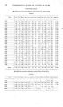
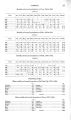
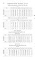
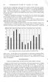
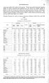
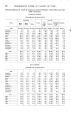
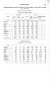
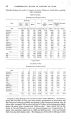
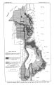
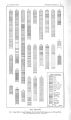
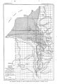
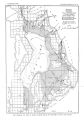
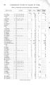
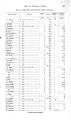
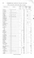
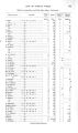
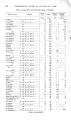
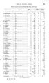
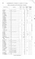
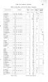
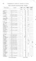
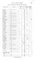
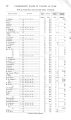
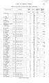
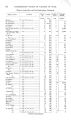
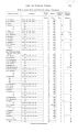
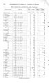
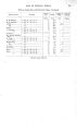
Show OCCURRENCE OF UNDERGROUND WATER. 53 Records of wells in the vicinity of Springville show rather uniform conditions. The town generally is underlain by gravel 5 to 40 feet thick, below which blue clay occurs to a depth of about 130 feet, underlain by sand and gravel down to 180 feet; then about 50 feet of light- colored clay is encountered, followed by sand and gravel at a depth of about 230 feet. In the area nearer the lake the top gravel generally is wanting, but otherwise similar sections are reported in that locality. Flowing wells are obtained from the two lower gravel horizons at depths of approximately 130 and 230 feet. The common occurrence of water at these two horizons implies unusual uniformity of underground conditions, and suggests a low lakeward dip, approximately corresponding to the surface inclination. The wells'are commonly 2' inches in diameter, though a few are 3 inches, and they yield on an average possibly 20 to 50 gallons a minute. One of the best in Springville is a 3- inch well belonging to A. Cox. It is 230 feet deep, flows about 120 gallons a minute, and its water is reported to rise in a pipe to a point 18 feet above the surface. The Rio Grande Railway Company has two wells in Springville, which are 216 and 304 feet deep. In the deeper the first flow was struck at 126 feet, a second at 216, a third at 260, and a fourth at 292. The shallower well is 3 inches in diameter, and is reported to flow about 200 gallons a minute at the surface, which is reduced to about 12 gallons a minute at the top of a tank about 30 feet above the surface. Mapleton Bench is the local name for the Provo Delta, lying between Spanish Fork and Hobble Creek. The delta is here prominently developed, and constitutes valuable farming land. Flowing wells are not obtained on Mapleton Bench because of its elevation, but there are a number of dug wells. It is reported that in the early days the wells on the bench were 60 feet or more in depth, but since irrigation has been practiced the groundwater level has been considerably raised, and now the wells average possibly only 30 feet in depth. There is a marked difference in the depth to ground water in winter and summer, the range in some instances amounting to over 10 feet. A'ong the outer margin of the bench there is a line of springs, many of which did not exist before the ditches were dug. Big Hollow Creek, a stream that flows from the bench about 2 miles south of Springville, is a conspicuous example. In the early days scarcely any water is said to have flowed in its channel, whereas it now irrigates over 100 acres. Considerable amounts of water are obtained by a few tunnels that have been dug along the eastern edge of Mapleton Bench. The entrances to the tunnels are commonly at the sites of springs. Some begin and end in unconsolidated materials, while others penetrate bed rock. The longest noted is in sec. 24, T. 8 S., R. 3 E. Its length is 275 feet. Water enough to irrigate about 100 acres comes through crevices in bed rock. SPANISH FORK, PAYSON, AND VICINITY. The town of Spanish Fork is situated on the general lowland at the base of Mapleton Bench and immediately north of Spanish Fork, about 5 miles below the mouth of its canyon. From the few well records available it appears that sand and gravel commonly underlie the surface to a depth of about 30 feet and are succeeded by 150 feet of clay, below which water- bearing gravel is usually encountered at a depth of 180 feet. The log of the well recently completed at the San Pedro station, about a mile west of the town, shows a greater thickness of clay, amounting to 205 feet, beneath which sand and clay were found to 390 feet, where water- bearing gravel occurs. Spanish Fork is rather poorly supplied with underground water. Dug wells commonly reach water at depths ranging from 10 to 25 feet, but its quality is not good. Flowing wells were formerly obtained, but in recent years the flows generally have ceased and pumping has to be resorted to. A city waterworks system was installed in 1904, the supply being derived from Evans Spring, near the mouth of Spanish Fork Canyon, about 5 miles above the town, and an excellent supply is now available. The line separating flowing and nonflowing wells now lies in the extreme northwest corner of the town. The first flow occurs at a depth of about 180 feet and a second flow between 350 and 400 feet. The creamery well, 2 inches in diameter and 220 feet deep, is typical. Water was struck at 180 feet |