| OCR Text |
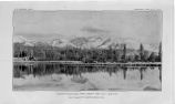
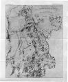
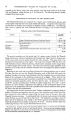
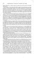
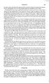
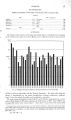
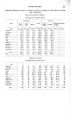
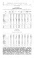
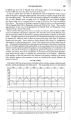
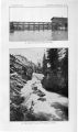
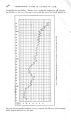
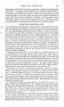
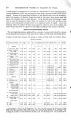
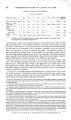
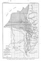
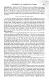
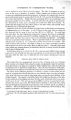
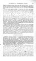
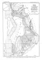
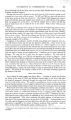
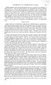
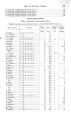
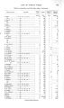
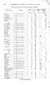
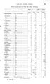
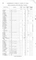
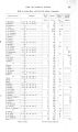
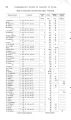
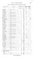
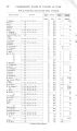
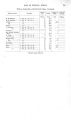
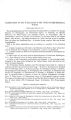
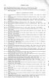
Show 1 8 UNDERGROUND WATER IN VALLEYS OF UTAH. occurs from June to September, and for these four months amounts to less than 3 inches. Between October and May the variation*^ not marked, but the greatest precipitation occurs in March and April ( fig. 2). This precipitation is unusually high for the Great Basin. The Wasatch Mountains serve to condense the moisture, originally derived in large part from the westerly winds from the Pacific Ocean, that remains in the air after crossing the Sierra Nevada. Probably the precipitation is greater on the summits than at the stations where records have been kept, but data are not available. The melting snow of the winter's accumulation is the chief supply of the streams of the area under consideration. The mean annual temperature of Salt Lake City is 51.4°. The mean monthly maximum ranges from 98° in July to 51° in January, while the mean monthly minimum varies between 10° in December and February and 50° in August. The dryness of the atmosphere is indicated by the mean relative humidity of 49 per cent, varying from 28 per cent in July to 76 per cent in January, and by the amount of evaporation from a free water surface, which, according to the latest measurements, is about 60 Per cent 14 Jan. Feb. Man Apr May June July Aug. Sept. Oct. Nov. Dec. 12 , 10 e 6 4 2 1 I o Jnches 1.44 1- 33 2.03 221 1.62 .79 .1S3 .72 .93 1.54 1.36 1.64 FIG. 2.- Diagram showing mean monthly precipitation at Salt Lake City. Mean annual 16.19 inches a year. Yet the climate is not nearly as dry as in other parts of the Great Basin. The dryness lessens the effect of the summer's heat, so that the " sensible temperature" is not so great as would be suggested by the thermometer, being modified by the cooling effects of evaporation. HYDROGRAPHY. STREAMS TRIBUTARY TO UTAH LAKE AND JORDAN RIVER. Seepage from surface streams, as shown hereafter, is the most important source of supply of underground water in the valleys of Utah Lake and Jordan River. A summary of discharge measurements therefore throws important light on the subject and, with other data, furnishes facts for roughly estimating the amount of water available for the annual replenishment of the underground reservoirs. The figures here given have been compiled from records of the United States Geological Survey and from data obtained through the courtesy of the city engineer of Salt Lake City, and are now published for the first time. Satisfactory measurements of the flow of all the streams in the two valleys have not been made. However, records have been kept for a number of years of the discharge of several of the more important, and the combined data, with due consideration for varying conditions, may be taken as typical of the drainage of the entire watershed. The measure- |