| OCR Text |
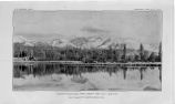
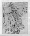
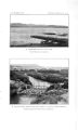
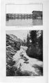
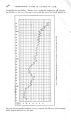
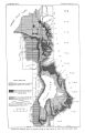
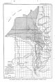
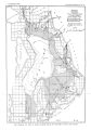
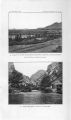
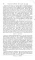
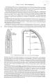
Show 1 TOPOGRAPHY AND DRAINAGE. 7' gishly in a broad valley, and in that distance falls only about 10 feet. In the " narrows," however, the river occupies a constricted channel and descends rapidly; in the first mile below the intake of the canals its fall amounts to about 70 feet. Below the " narrows" the valley spreads out and at its greatest width is about 18 miles wide. The country rises gradually toward the adjacent highlands to the base of the terraces that mark the shore lines of Lake Bonneville, whence the ascent is by successive steps. Between Salt Lake City and Great Salt Lake the topography is almost flat, and a number of small lakes of shifting outline occupy local depressions. As the shore of Great Salt Lake is approached there is a faint slope of the surface which becomes increasingly marshy. This area west of Salt Lake City in general is barren and desolate and the surface in many places is white with alkali. On the uplands, away from the lake, alkali is scarce, but the western part of the valley, because of the lack of water, suffers in comparison with the cultivated eastern part, which is supplied by streams from the Wasatch Mountains. North of the Traverse Mountains the principal tributaries of Jordan River are City, Red Butte, Emigration, Parleys, Mill, Big Cottonwood, Little Cottonwood, Dry Cottonwood, and Willow creeks, all of which issue from the Wasatch. In their mountain courses these creeks generally occupy narrow canyons from which they emerge on the lowlands and flow in broad open valleys to the Jordan. Within the mountains they are all perennial streams, but at the mouths of the canyons their flow is largely diverted by irrigation ditches, so that, in the dryest part of the year, their lower courses are generally dry. They rise in the main crest of the Wasatch and have small watersheds, Big Cottonwood Creek, draining about 48 square miles, being the largest. This stream rises at the base of Clayton Peak, is fed by a number of small lakes, and discharges a considerable quantity of water through a narrow canyon ( P1. IV, JS). The vegetation is scanty. The valleys in their natural state are occupied by sagebrush, greasewood, and kindred desert plants, but wherever water is available there is a marked contrast, and the irrigated areas of these valleys rival in productiveness any in the country. Sugar beets are grown in quantity; alfalfa, potatoes, corn, etc., are common crops; and on the bench lands a variety of fruits are successfully cultivated. The mountains on the western border are generally barren; sagebrush and occasional cacti are the chief growths on the slopes, while scrub oak and stunted spruce and pine here and there grow in patches; the summits are usually bare. The Wasatch Mountains are more favored, but they do not support a heavy growth of trees. At the heads of the valleys scattering pine, juniper, mountain mahogany, and quaking aspen locally occur, and cottonwood, birch, and maple are often found near the stream beds. The slopes are commonly covered with underbrush in varying degrees of thickness, sagebrush and scrub oak being prominent. GEOLOGY. LITERATURE. This area has been studied by prominent geologists and has inspired some classic works on American geology. King, Emmons, and Hague of the Fortieth Parallel Surveys interpreted the main features of the region, and Gilbert made it famous by his investigation of Lake Bonneville. b But although this interesting region lies contiguous to one of the main transcontinental routes and has been visited by many geologists, yet comparatively little detailed work has been done in it. Walcottc has studied the Big Cottonwood Cambrian section, G. O. Smith and G. W. Tower d have examined the Tintic district, J. E. Spurre has a King, Clarence, Systematic geology: Rept. Geol. Explor. 40th Par., vol. 1,1872; Hague, Arnold, and Emmons, S. P., Descriptive geology: Ibid., vol. 2, 1877. b Gilbert, G. K., Lake Bonneville: Mon. U. S. Geol. Survey, vol. 1, 1890. c Walcott, C. D., Bull. U. S. Geol. Survey No. 30, 1886, p. 38. d Tower, G. W., and Smith, G. O., Geology and mining industry of the Tintic district, Utah: Nineteenth Ann. Rept. U. S. Geol. Survey, pt. 3, 1898, p. 601. eSpurr, J. E., Economic^, geology of the Mercur mining district, Utah. Sixteenth Ann. Rept. U. S. Geol. Survey, pt. 2,1895, p. 343. |