| OCR Text |
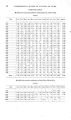
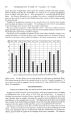
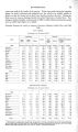
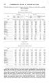
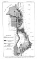
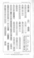
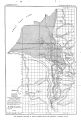
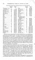
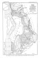
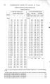
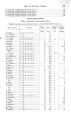
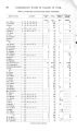
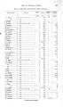
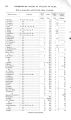
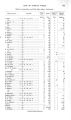
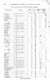
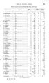
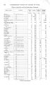
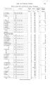
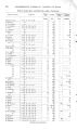
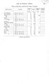
Show 46 UNDERGROUND WATER IN VALLEYS OF UTAH. feet. At greater depths the succession appears to be more variable, but there are few satisfactory well records. Ground water now lies within 10 feet of the surface over practically the entire lowland area, but it is reported that in the early days it did not lie so near over so large an area. Present conditions are largely due to irrigation. Several old residents state that below the level of the Jordan ' River canals the ground- water surface has locally risen 40 or 50 feet since their construction. It has already been mentioned' that along several of the drainage ways seepage water reappears at the surface and occasionally forms considerable streams, as at Spring Creek near its junction with Big Cottonwood Creek, where the September flow is estimated to amount to 14,000,000 gallons a day. In many places also, especially along the bases of benches, lines of seep springs occur that furnish considerable flows, a notable occurrence being those at the nursery in the southeastern part of Salt Lake City. But locally, as along the bluff east of Jordan River, north of the Bingham Junction smelters, the water appears at so low an elevation as to be of comparatively little use. When pumping becomes more generally practiced in the valley this ground water that lies so near the surface can be easily developed. Flowing wells in this area are numerous. They are generally 2 inches in diameter and 100 to 400 feet in depth, and they commonly yield between 20 and 50 gallons a minute, though there are many variations. The pressure is low, generally less than 10 pounds. Well drivers say that their best results are obtained in belts extending northwest and southeast, parallel with the creeks, and that these productive belts are separated by relatively barren ones. The water- bearing sands and gravels apparently mark the courses of old waterways, while finer- textured material was deposited in the intervening arees These distinctions have been noticed only in the upper parts of the lowland area, and near the river they are said to disappear. One of the best wells is at the plant of the American Smelting and Refining Company at Murray. It is 4 inches in diameter, 400 feet deep, and is reported to flow about 400 gallons a minute under a pressure of 3 pounds per square inch. The record of this well is given as follows, on the authority of H. F. Yeager, well driller: Record of American Smelting and Refining Company's well at Murray. Thickness in feet. Sand and gravel 5 Mud 3 Sand and gravel 4 Blue clay 6 Quicksand 10 Blue clay 8 Loose sand and gravel ( good pump well at 42 feet) 16 Jlue clay 8 Quicksand ( flow at 63 f e e t ) . . . 6 Blue clay. 18 Yellow clay 6 Loose sand and gravel ( strong flow at 95 feet) 15 Yellow clay 3 Coarse gravel and rock ( strong flow at 112 feet, and at this point the well at ^ office stopped flowing) 8 Coarse grave] and rock 6 Quicksand 20 Clay, very hard..-. 10 Quicksand 6 Gravel ( small flow at 165 feet) 11 Depth in feet. 0- 5 5- 8 8- 12 12- 18 18- 28 28- 36 36- 52 52 60 60- 66 66- 84 84- 90 90- 105 105- 108 108- 116 116- 122 122- 142 142- 152 152- 158 158- 169 Thickness in feet. Hard pan, very hard 8 Blue c\&\ 6 Quicksand ( flow at 203 feet).. 20 Quicksand 16 Blue clay 4 Quicksand 7 Blue clay 8 Quicksand ^. 18 Blue clay and quicksand in layers 2 feet thick 22 Quicksand 8 Blue clay, very hard 12 River sand 2 River sand 1 7 Cemented gravel 12 Yellow clay 7 Cemented gravel 17 Loose gravel. 23 Yellow clay 2 Gravel.. _ 7 Cemented gravel 12 Loose gravel 12 Depth in feet. 169- 177 177- 183 183- 203 203- 219 219- 223 223- 230 230- 238 238- 256 256- 278 278- 286 286- 298 298- 300 300- 307 307- 319 319- 326 326- 343 343- 366 366 368 368- 375 375- 387 387- 399 |