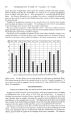
| OCR Text |
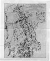
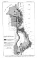
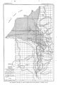
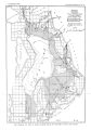
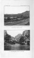
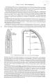
Show GEOLOGY. 9 Between City and Big Cottonwood creeks the summit and western face of the mountains are occupied by an immense syncline striking nearly east and west. Its western end is terminated by the Wasatch fault, which cuts directly across the fold and exposss the structure so that it can be plainly seen from Jordan Valley. The axis of the syncline coincides approximately with the course of Emigration Creek. In detail, however, the structure is complicated by a number of relatively minor disturbances. East of Salt Lake City upper Carboniferous and Permian strata, consisting chiefly of limestone, outcrop between City and Red Butte creeks, and dip southward, forming the northern limb of the syncline. Red Butte Canyon lies in Permo- Carbonifsrous rocks, but near the mouth of the canyon " Red Beds" outcrop and continue along its southern divide. The " Red Beds" consist chiefly of red shales and sandstones, aggregating over 1,000 feet in thickness and are overlain by thin- bedded, argillaceous limestones and shales of Jurassic ags. These rocks occupy the center of the syncline, and outcrop in the valley of Emigration Creek. South of Emigration Creek the summit and western face of the Wasatch Mountains are occupied by the southern limb of the syncline as far as Big Cottonwood Creek, and the succession of rocks mentioned above is repeated in reverse order. The dips generally are northward, but there are minor folds and faults. Parleys Creek rises in the Cretaceous sandstone and conglomerate that, east of the main Wasatch ridge, lie unconformably upon the older rocks. After traversing this area it crosses a narrow belt of Red Beds and, for 5 miles above the mouth of its canyon, flows over calcareous and argillaceous Permo- Carboniferous rocks. Carboniferous strata occupy the divide between Parleys and Mill creeks, the latter of which flows for the greater part of its length in the Weber quartzites. Between Mill and Big Cottonwood creeks the lower Paleozoic rocks outcrop. Big Cottonwood Creek exposes for 6 miles above the mouth of its canyon a great thickness of Cambrian strata, consisting of siliceous slates and quartzites; in the upper part of its course this creek crosses the Webar quartzite and Wasatch limestone, and heads in the crystalline rocks of Clayton Peak. Little is known of the occurrence of Silurian and Devonian sediments in this area. Their presence was recorded by the early surveys, but the little detailed work that has been done shows that in a few localities at least these systems do not appear to be represented by sediments. Little Cottonwood Creek for about 8 miles from the mouth of its canyon flows through a crystalline area, and heads in Paleozoic strata and igneous rocks at the foot of Clayton Peak. The western base of the mountains extending north and south of Little Cottonwood Creek is occupied by a belt of schistose rocks about 10 miles long and averaging perhaps 1 mile in width. These rocks are of pre- Cambrian age and are over a thousand feet thick. They consist largely of quartzite, but include also slates and mica- schists, having an apparent steep western dip. Up Little Cottonwood Creek, beyond the pre- Cambrian area, lies a large body of granitic rocks, which forms high peaks north and south of the creek, and through which the stream flows for the greater part of its course. The Paleozoic sediments arch around this granitic area, dipping away from it to the north, east, and south, forming a dome the western part of which has been cut off by the Wasatch fault. The age of the " Little Cottonwood granite" has been the subject of some discussion. It clearly cuts the pre- Cambrian rocks at the mouth of the canyon, but its relation to the Cambrian was not definitely determined by the early surveys, though the granite was thought to be of pre- Cambrian age. Recently, however, it has been shown a that the " granite" is an intrusive mass that cuts the Cambrian quartzite, though the age of the intrusion is not yet known. Partial topographic connection between the Wasatch and Oquirrh ranges is maintained by the Traverse Mountains near the head of Jordan Valley, but this connection furnishes, little information concerning the relations of the two main mountain masses, because- the a Emmons, S. F., Am. Jour. Sci., 4th ser., vol. 16, August, 1903, p. 139. |