| OCR Text |
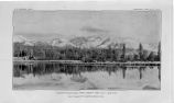
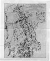
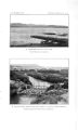
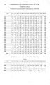
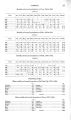
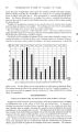
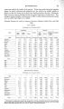
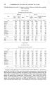
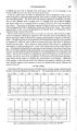
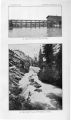
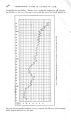
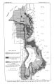
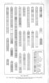
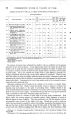
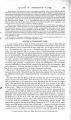
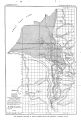
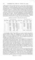
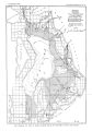
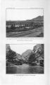
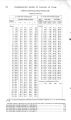
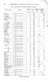
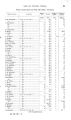
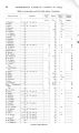
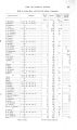
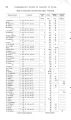
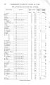
Show 2 4 UNDERGROUND WATER IN VALLEYS OF UTAH. for the period August 1903, to August, 1904, under the direction of G. L. Swendsen, a of the United States Reclamation Service, who found that of the total supply of 604,010 acre-feet only 471,140 were contributed by rainfall on the lake and by the measurable surface streams, leaving an unmeasured supply of 132,870 acre- feet. This considerable amount appears to be contributed by seepage and by springs, some of which have recently been found in the northwestern part of the lake. The surface of the lake is subject to considerable variation in elevation in consequence of the changing relations of evaporation, precipitation, inflow, and outflow. Fig. 3, prepared by the Reclamation Service, shows fluctuations of the surface from 1889 to 1904. There is a seasonal variation of 1 to 4 feet, ranging from a minimum in the late fall to a maximum in late spring and early summer. The diagram also shows the variation in the mean- level of the lake. The lowest elevation shown occurred in 1903, when the lake was about half a foot lower t h a n it was in 1889. Following 1889 was a period of ten years of relatively high water. J O R D A N RIVER. During the last few years anomalous conditions have existed at the outlet of Utah Lake. The water level of the lake has fallen so low t h a t the normal flow has ceased, and in order to supply the canals in Jordan Valley it has been necessary to resort to pumping. Accordingly a pumping plant has been in operation at the head of Jordan River since August, 1902. ( PI. IV, A.) The following table of discharges has been prepared by Mr. J. Fewson Smith, jr., water commissioner: Discharge of Jordan River and the canal systems in Jordan Narrows, and of Jordan River at pumping plant, April to October, 190^. [ Acre- feet.] Month. 1904. April May June July August September... OctobTero tal. North Jordan. East Jordan. 963 2,970 3,384 3,233 2,662 753 650 3,036 5,701 5,369 5,186 5,280 1,920 13,965 I 27,142 City. 596 452 3,199 3,090 1,373 South Jordan. 647 5,167 6,648 5,407 5,031 5,357 2,134 9,109 | 30,391 Utah and Jordan Salt River at Lake. weir. 720 4,150 7,878 6,719 7,110 7,992 3,367 37,936 Sum of preceding. 75 2,911 4,225 3,894 3,668 2,767 310 17,850 2,092 16,823 27,874 27,972 27,318 25,431 136,393 Jordan River at pumping plant A 222 18,090 25,110 25,210 24,720 23,330 8,363 125,045 a Figures furnished by G. L. Swendsen. From these figures it appears t h a t the gain in t h e flow of Jordan River between the pumping plant and the intake of the canals in Jordan Narrows, a distance of about 13 miles, April to October, 1904, was 11,348 acre- feet. The gain is partly supplied by seepage and partly by the flow of wells and springs. Between Jordan Narrows and the head of North Jordan canal, a distance of about 9 miles, Mr. J . Fewson Smith, jr., found that the seepage into Jordan River between May and September, 1904, amounted to 13,789 acre- feet. a The writer acknowledges his indebtedness to Mr. Swendsen for many courtesies extended, both in the field and office, during the prosecution of the work. |