| OCR Text |
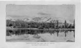
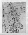
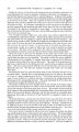
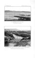
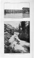
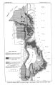
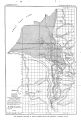
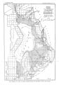
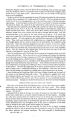
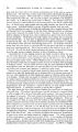
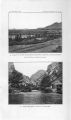
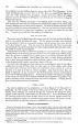
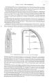
Show UNDERGROUND WATER IN THE VALLEYS OF UTAH LAKE AND JORDAN RIVER, UTAH. By G. B. RICHARDSON. INTRODUCTION. The valleys of Utah Lake and Jordan River are situated in north- central Utah, in the extreme eastern part of the Great Basin. The lofty Wasatch Range ( PI. I), the westernmost of the Rocky Mountain system, limits the valleys on the east, and relatively low basin ranges- the Oquirrh, Lake, and East Tintic mountains- determine them on the west. The valleys trend north and south, and are almost separated by the low east- west Traverse Range, the slopes of which constitute a dam for Utah Lake, which drains through Jordan River to Great Salt Lake. The area under consideration is the most populous and nourishing part of the State. Salt Lake City and Provo, the first and third cities in the State, and many other thriving settlements are there located. At Bingham Junction and Murray a number of smelters treat the ores from near- by mines, but agriculture is the main industry. Water for irrigation is supplied by mountain streams, and intensive farming is successfully pursued. The practice of irrigation was begun by the Mormon pioneers in 1847, and has been discussed in several publications; little attention, however, has been given to the underground water resources, and, so far as the writer is aware, they have not before been described. The present paper outlines conditions of occurrence of the subterranean waters and describes their development in the valleys of Utah Lake and Jordan River. TOPOGRAPHY AND DRAINAGE. The drainage area of Utah Lake and Jordan River is approximately 3,300 square miles, of which 2,600 are tributary to Utah Lake and 700 to the Jordan north of the Traverse Mountains ( PI. II). About 2,000 square miles of the watershed are in the Wasatch Mountains, while the valleys themselves cover a little less than 1,000 square miles. Utah Lake Valley is about 38 miles long, averages 15 miles in width, and occupies about 560 square miles, including Utah Lake. Jordan Valley is approximately 28 miles long, 15 miles wide, and comprises 420 square miles. These valleys in late geologic time were occupied by Lake Bonneville, the Pleistocene predecessor of Great Salt Lake, and to that fact is due their characteristic topography. Almost flat unconsolidated lake sediments underlie the broad valleys, the borders of which are marked by a unique series of terraces that characterize the shore lines of the old lake. Descriptive details of these features will be given in the sections devoted to geology and to the occurrence of underground water. The range in elevation is considerable. The present level of Great Salt Lake is approximately 4,210 feet above the sea, and that of Utah Lake is about 4,480 feet. From these lowest elevations the two valleys rise to their outer borders, which may conveniently be taken as the highest level occupied by Lake Bonneville, at approximately the 5,200- foot contour, above which the Wasatch Range towers up to 12,000 feet. The mountains on the west are narrow north- south ranges that rise abruptly from broad valleys. The 5 |