| OCR Text |
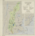
Show At the present time, 127 stream flow, 16 sediment, and 5 chemical quality of surface water stations are maintained on the main stream above El Paso and the larger tributaries. These include stage and contents records of the major reservoirs. Only a limited amount of hydrologic data are being ob- tained in large irrigated areas where serious water- logging has occurred. Only fragmentary informa- tion is being obtained to determine runoff and other related information for small watersheds under 100 square miles in area. The International Boundary and Water Commis- sion operates a network of stream flow, chemical quality, and sediment stations on the Rio Grande at and below El Paso and on the lower reaches of tributary streams along the international border. The Department of Agriculture is conducting sur- veys on sample areas in connection with flood con- trol surveys on the minor tributaries of the Pecos River and the Rio Grande above Fort Quitman to secure stream runoff, sedimentation, and infiltration data. Ground water investigations call for a limited network of ground water observation wells to show water table fluctuations. These investigations further include studies of occurrence, quantity, and chemical quality of water from water-bearing for- mations. Present investigations are chiefly of a re- connaissance nature. Future plans provide for the expansion of these investigations to provide more adequate information. About 10 percent of the Rio Grande Basin is covered by geologic maps of adequate scale. Many of the existing maps treat almost exclusively the sub- surface mineral resources, so that information on ground conditions as they affect engineering works is inadequate. Plans of the Geological Survey pro- vide for 24 geologic mapping projects within the next 6 years. Of these 24 projects, 5 are to be di- rected toward supplying geologic maps of areas where larg^e construction activities are planned in the future. The other projects are studies of fuel resources a.nd ore deposits. Topographic maps are available for less than one- half of the Hio Grande Basin. While most maps are usable in some preliminary planning activities, only about 10 percent are adequate for present require- ments. Tfie largest block of modern topographic maps covers an area in the vicinity of El Paso, and consists of 24 contiguous 15-minute quad- rangles. Xhe largest current mapping project in the basin lies directly north of this area on both sides of the Pecos River and includes 44 7J/2- minute quadrangles. Other active projects are in the vicinity of Albuquerque and Los Alamos, and a large area east of El Paso. Cadastral surveys fix the boundaries on which all land descriptions, areas, and titles are based. They constitute the one authoritative control for any land resource activity in fixing property line location and ownership. They are, therefore, necessary in connection with any type of water resources activity relating to land use. A large portion of the Rio Grande Basin lying in Colorado and New Mexico is not covered by adequate cadastral surveys. Approximately 30 percent of the total land area of New Mexico never has been covered by ca- dastral surveys or the original surveys must be re- made because markers have become obliterated. Data for the proper planning of the water pollu- tion control program within the Rio Grande Basin are inadequate. This lack is due, in large part, to the fact that water pollution is viewed with such minor concern by States of the basin that there have been no funds for, nor interest in, sustaining a coordinated program. State water pollution ac- tivities are principally confined to routine sanita- tion and short investigations of complaints, neither of which is productive of data required for a com- prehensive programs of pollution abatement. The least understood and most controversial question in the watershed hydrology of the upper Rio Grande is the degree of influence of forest and grass cover and of soil conservation measures on the water yield from precipitation on watersheds. This question requires an authoritative answer. The Department of Agriculture is conducting certain basic investigations and surveys pertaining to effects of vegetal cover on runoff and erosion, reseeding and reforestation, soil management in connection with irrigation and drainage, sedimen- tation surveys, erosion control and water conserva- tion, range management, snow surveys, aerial pho- tography, and forest and range resources investi- gations. These data are being collected and com- piled in an effort to provide additional basic infor- mation required for an adequate water and related resources program in the basin- Basic soil surveys are available for only about 5 percent of the land area of the basin. Most of the lower basin, that portion within Texas on the lower Rio Grande and lower Pecos River drain- 334 |


