| OCR Text |
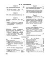
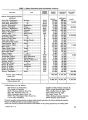
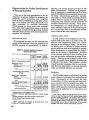
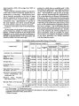
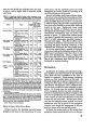
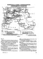
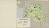
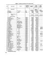
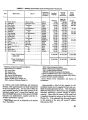
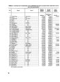
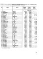
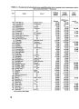
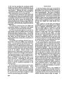
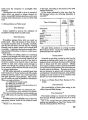
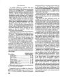
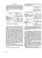
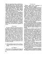
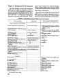
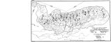
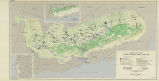
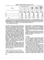
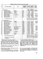
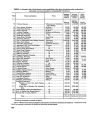
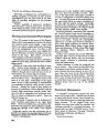
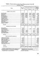
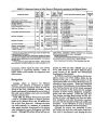
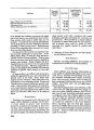
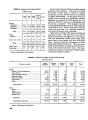
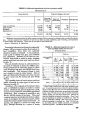
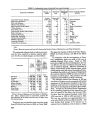
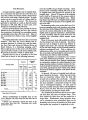
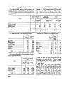
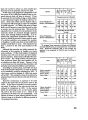
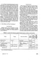
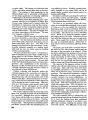
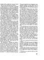
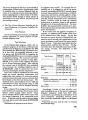
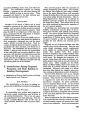
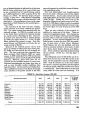
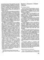
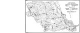
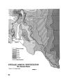
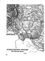
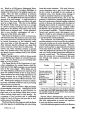
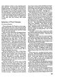
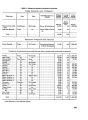
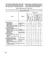
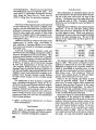
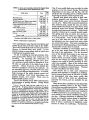
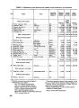
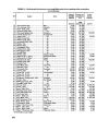
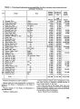
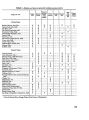
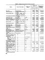
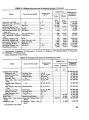
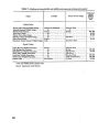
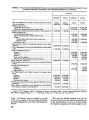
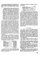
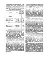
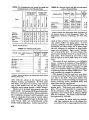
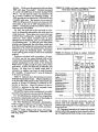
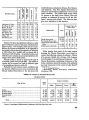
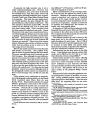
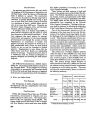
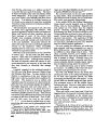
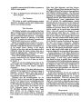
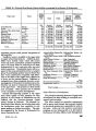
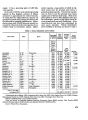
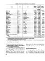
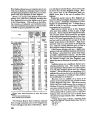
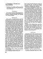
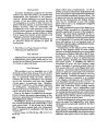
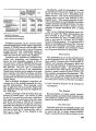
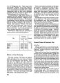
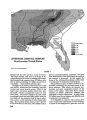
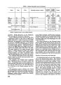
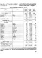
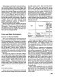
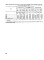
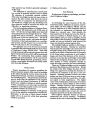
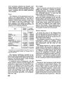
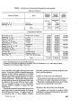
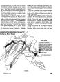
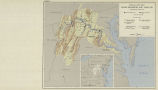
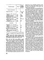
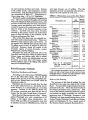
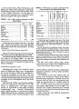
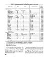
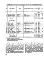
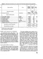
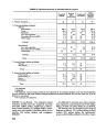
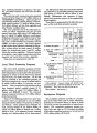
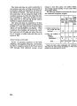
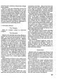
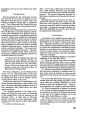
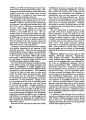
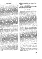
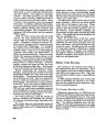
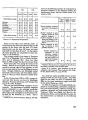
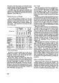
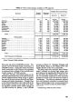
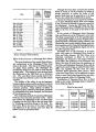
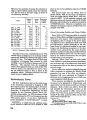
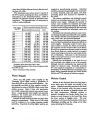
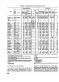
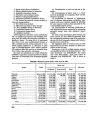
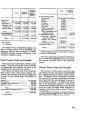
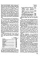
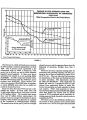
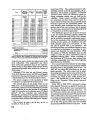
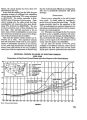
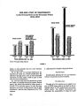
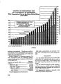
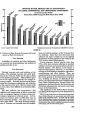
Show TABLE 13.-Sedimentation rates as developed from reservoir surveys Reservoir and location Storage ca- pacity Watershed area Annual sedi- mentation rate Parent material of princi- pal soils Lake of the Ozarks, Missouri..... Split Rock, Minnesota........... Kirk Lake, Kansas.............. Mission Lake, Kansas........... Belle Fourche, South Dakota..... Olathe, Kansas................. Jones Creek, Iowa.............. Leavenworth. County Lake, Kansas Baker, Montana................ Guernsey, Wyoming............. Buffalo Bill, Wyoming........... Mitchell, South Dakota.......... Wellfleet, Nebraska............. Cucharas, Colorado............. Tongue River, Montana......... Acre-feet 2, 087, 223 899 111 1,852 208, 850 721 75 3,916 756 73, 810 455, 838 11,190 519 38, 274 72, 510 Square miles 13, 908 41 2 8 4,480 6 2 4 5.2 i 5, 500 1,470 496 43 608 1,740 Percent 00.31 2.11 .91 1.20 .19 1.91 2.00 .23 1.15 1.67 .11 .25 1.89 1.47 .45 Cherty limestone. Limestone. Shale. Do. Shale and sandstone. Shale. Loess. Shale. Do. Do. Igneous rocks. Glacial till. Shale. Do. Limestone, shale. iNet. Source: Reservoir survey data from Soil Conservation Service, Bureau of Reclamation, and Corps of Engineers. The estimated sediment load at various reservoirs and the time required to deplete capacity allow- ance for silt (or dead storage) are shown below. Source: Corps of Engineers and the Bureau of Reclama- tion. These estimates may be conservative, because the trap efficiency of the larger reservoirs may be higher than that assumed, here. Total cost per acre-foot for these reservoirs varies from $7.18 at Fort Peck to $480 at Cedar Bluff. 218 The figure for Garrison is $9.35, $19.10 for Boysen, $58.60 for Harlan County, and $84.10 for Heart Butte. In connection with the investigations at Garri- son a preliminary study was made of the cost of desilting Missouri River water. Based on 1940 prices and a high load factor desilting plant, the cost was $50 per acre-foot of sediment removed, exclu- sive of sediment disposal. Effective desiltation of inflow would require a high capacity plant, which would largely stand idle except during flood flows. In addition the problem and expense of disposing of the removed sediment (48,000 acre-feet annually at Garrison) would be great. The procedure was not considered practicable for so large a reservoir. The sediment removal cost estimate of $50 per acre-foot at Garrison may be compared with actual experience in this operation elsewhere in the basin. Desilting works have been constructed at the Loup River power development in the Platte River Basin, Nebr. Analysis by the Federal Power Commission of the operating experience of the Loup River Dis- trict, as reported by the district for the years 1940- 44, show that the material dredged varied from 1,249 acre-feet in 1940 to 2,583 acre-feet in 1942. The cost per acre-foot was approximately in in- verse ratio, $79.81 in 1940 and $46.41 in 1942. The costs include fixed charges of 7.9 percent on an estimated cost of desilting works of about a million Esti-Snufl Esti" Dead St ™£* Reservoir or silt inflow , , , capacity under ££« tions Acre-feet Acre-feet Tears Fort Peck.. _............4,500,000 2,200 2,000 Garrison____............4, 900,000 47, 760 102 Oahe...................5, 500,000 40,100 137 Ft. Randall..............1, 400, 000 25, 200 56 Harlan County.......... 200,000 2,000 100 Pomme de Terre......... 10,000 200 50 Boysen.................. 260,000 5,300 50 Heart Butte............. 25,000 145 172 Cedar Bluff.............. 51,400 249 200 |