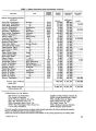
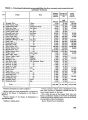
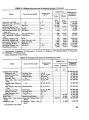
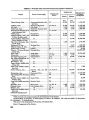
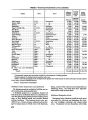
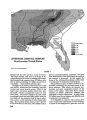
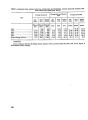
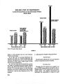
| OCR Text |
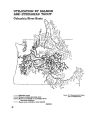
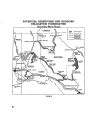
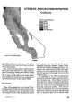
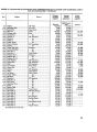
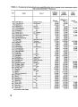
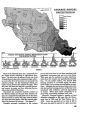
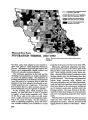
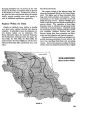
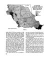
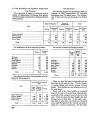
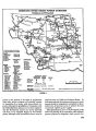
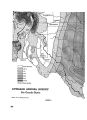
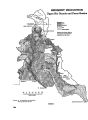
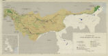
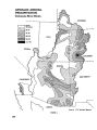
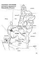
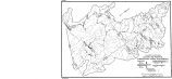
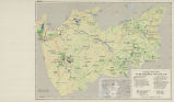
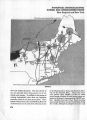
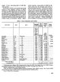
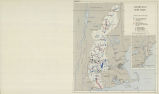
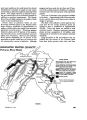
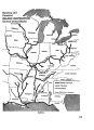
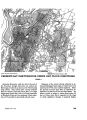
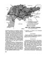
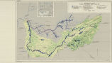
Show flow during dry seasons. Additional stations are currently being established to provide such informa- tion over a wider range of conditions than now are sampled. Another phase of water loss is through evapora- tion. Accordingly, a program of gathering evapo- ration data is under way. Present facilities permit collecting about half the total information needed. Better data are available for the upper part of the basin than for the lower. Ground water data are deficient. Preliminary reconnaissance data are available for western Ten- nessee, but largely absent elsewhere. With increas- ing use of ground water for industrial and domestic uses, knowledge of ground water availability, re- charge areas, and quality will be more and more essential. Some information is available on surface water quality. This has been deemed adequate insofar as present vises are concerned, especially in the upper part of the basin. With marked industrial expan- sion and many needs for water of specified chemical content, demand for additional data of this type will increase. The Public Health Service has obtained infor- mation on the sanitary quality of some of the more important streams and reaches of the main river. This has served to give an over-all picture of the character of the surface waters, but in view of the now intensive use of the Tennessee water for recreation and wildlife, and increased industrial and domestic demands, present surveys are not sufficient. Much more data will be needed to es- tablish needs for waste disposal programs. Con- sequently a series of permanent Federal sanitary water stations is essential. As reservoirs were constructed, care was taken by TVA *o obtain accurate information on the topography of the reservoir area. This is used in connection, with later measurements along specified courses in reservoir surveys to determine the amount of sedimeritation in the reservoirs. The TVA has undertaken a systematic program of reservoir sur- veys to keep information on sedimentation up to date. Accurate topographic maps are essential in sound basin planning. The TVA early sponsored a pro- gram of topographic mapping to a high standard. As a result probably two-thirds of the basin has now been covered. Although additional areas remain to be covered, the more important headwater areas and reaches on which projects are located have been mapped. Similarly, TVA sponsored a program of soil mapping that has now covered about 60 percent of the basin. Most of the field maps are on aerial photographs. By contrast, geologic mapping has not progressed. Only scattered data on geology have been obtained, and the total area covered is relatively small. Although data to support the engineering phases of the TVA program have generally been obtained, essential data for watershed and land programs have not received the attention they deserve. As a result, only limited soils information is available, and this is largely generalized. In only a few coun- ties are sufficient soils data available for detailed planning. Biological data similarly are less than adequate. TVA and the Forest Service cooperated in a forest survey of the basin, but these data need to be brought up to date periodically in order to make forestry programs most effective. Other biological data are needed, such as on the fishery resource. TVA, in cooperation with State and other Federal agencies is conducting surveys and making fish studies, but further research is needed to understand food relations, the effect of temperature changes and of reservoir drawdowns, and changes in the sanitary quality and oxygen con- tent of the water. Wild fowl are wintering in increasing numbers in Tennessee Valley waters. Population and flight data are being obtained. Studies now under way are not sufficient to provide the best management of the water for these birds. Additional investiga- tion is needed of food requirements, opportunities for enhancing habitat conditions, and ways of pro- viding protection to migrants. Research is also needed on many phases of wa- tershed management. The TVA cooperates with the Department of Agriculture in such research. This should include detailed studies of erosion and methods of control, methods of land management to improve surface and ground water, and the ef- fects of various land treatments and practices. Among these are better methods of forest manage- ment to increase growth rates and quality, better logging methods, and forest practices that would improve stream flow and soil conditions. Conclusions The TVA has taken many steps to overcome de- ficiencies in basic data essential to the construction and operation of its projects, as well as the solution of engineering problems. 780 |