| OCR Text |
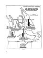
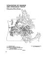
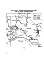
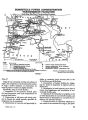
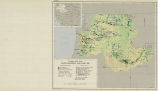
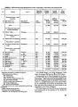
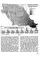
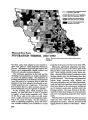
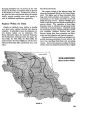
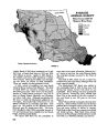
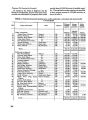
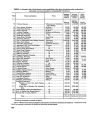
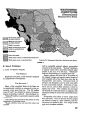
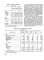
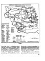
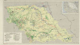
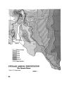
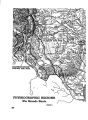
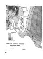
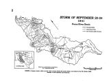
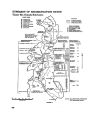
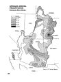
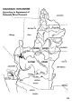
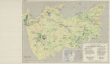
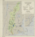
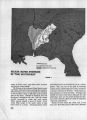
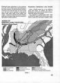
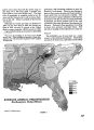
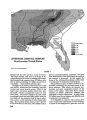
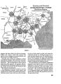
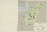
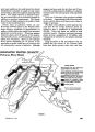
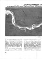
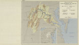
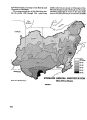
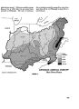
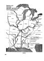
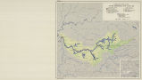
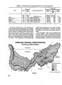
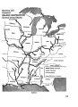
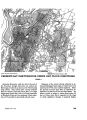
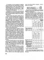
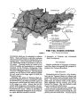
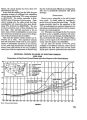
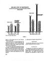
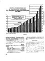
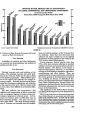
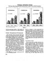
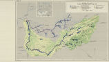
Show Flood Protection Area Protected, Character of Works, Amount of Storage The natural conditions affecting the water re- sources of the Alabama-Coosa Basin do not, in gen- eral, produce disastrous floods. Some 526,000 acres are subject to overflow, about 50 percent of which is cleared land. Present average annual flood damage is estimated to be $1,323,600. Eighty-five percent of the damage occurs in rural areas. About 326,- 000 acres subject to flooding are in the flat coastal plain along the Alabama River and its lower tribu- taries. Overbank flooding in this area is less fre- quent than above Montgomery. Damaging flood- ing below Montgomery, however, is just as frequent as above that city and lasts longer. Local flood protection works have been con- structed by the Corps of Engineers at Collinsville, Prattville, Rome, and along the Cahaba River be- low Centerville. These improvements consist of levees, flood walls, and channel improvement works which are being maintained and operated by local interests. The recently completed Alla- toona Darn and Reservoir on the Etowah River is the first major structure in the basin having storage especially for flood control. Of the total storage of 722,000 acre-feet in the reservoir, 389,000 acre- feet are reserved for flood storage. Facilities Under Construction and Authorized No Federal flood protection works are under construction in the basin. A channel improvement project on Black Greek near Gadsden has been au- thorized for construction. Detailed planning for Howell Mill Shoals Dam, authorized for navigation and power3 is considering provision for flood con- trol storage. Programs for Further Consideration The plan of the Corps of Engineers includes four items for clearing, snagging, and rectifying the channels of lesser tributary streams to increase their discharge capacity. Although only 1 of the 24 proposed reservoirs provides specifically for flood control storage, the degree of control of the rivers of the basin which will result from the completed plan will decrease materially present flood hazards. Flood control storage will be provided in others of these reservoirs to the extent that detailed plan- ning indicates advisable. Additional local flood protection work for Rome, Gadsden, Montgomery, and Selma are under study. Watershed Control Upstream and Related Land Uses Land Use Problems Intensive use of cultivated lands without pro- tective measures, overgrazing of grasslands and woodlands, and depletion of forests contribute to high runoff rates in the basin. Serious erosion has affected 75 percent of the land. Although most erosion occurs on cultivated lands, more than three- fourths of the forest land is in unsatisfactory water- shed condition. Grasslands, too, are in generally poor shape for use as watershed protectors. A large part of the cultivated land is devoted to the production of cotton and corn. Farming methods required to produce such open-tilled crops expose the soil to erosion and contribute to the rapid surface water runoff. From the standpoint of soil conservation, about one-fifth of all the culti- vated land is unsuited to such use. All but 750,000 acres of the remaining cultivated land require spe- cial measures to protect it from erosion. The needs for perennial cover, winter cover crops, and terracing are particularly urgent. Scattered throughout the basin are areas once cleared and used for crops which have been aban- doned because of erosion and soil depletion. These areas contribute materially to flood and sediment damage. Many can be profitably reclaimed and converted to excellent pasture. In other areas, the degree of erosion damage and the types of soil and slope are such that the most practicable conservation treatment is to convert the land to forest. Approximately 20 percent of the grassland may be classed as improved pasture. Other grasslands require soil treatment and improvement measures together with erosion control structures such as diversion terraces, contour furrows, and small dams. Some land now used for pasture has been severely damaged by gully erosion. The forests, which receive approximately two- thirds of the basin's precipitation, are strategic as a regulator of water. Bih a number of factors cut down their usefulness in this regard. Improper cutting bares the soil and leads to excessive erosion and surface runoff. Forest fires-man-caused fires which burn a large acreage every year-kill the protective cover of small trees and undergrowth and impair the water-absorbing capacity of the soil. 538 |