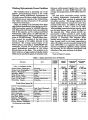
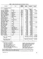
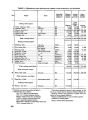
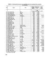
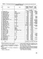
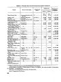
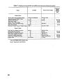
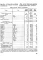
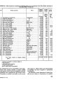
| OCR Text |
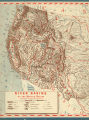
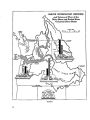
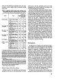
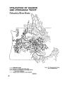
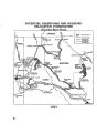
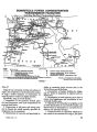
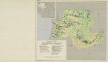
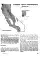
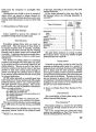
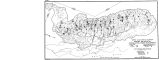
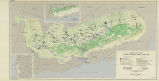
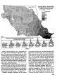
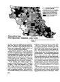
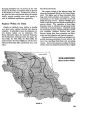
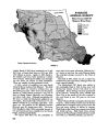
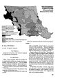
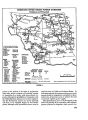
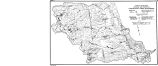
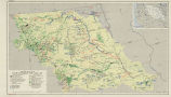
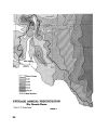
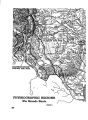
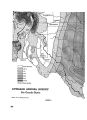
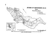
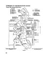
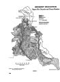
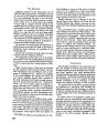
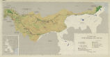
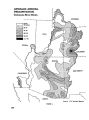
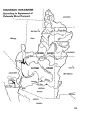
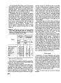
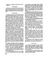
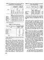
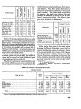
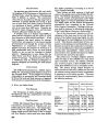
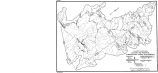
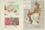
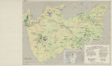
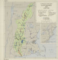
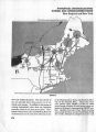
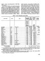
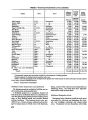
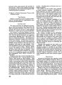
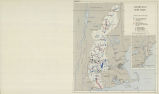
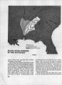
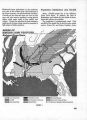
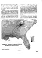
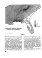
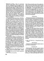
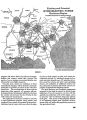
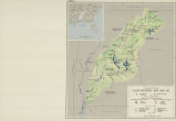
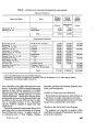
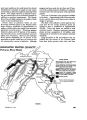
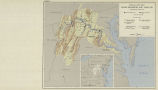
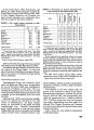
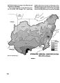
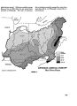
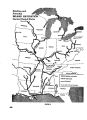
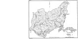
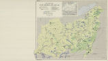
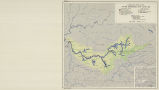
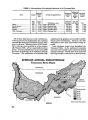
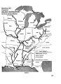
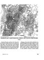
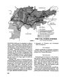
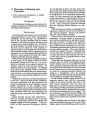
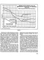
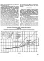
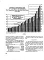
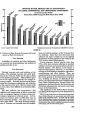
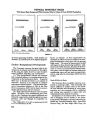
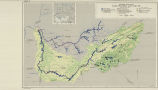
Show More people have moved to California since 1940 than live in the entire State of Iowa. The growth of industry and population has greatly advanced the local demands for electric power and food. To keep pace with these demands, attention will have to be directed toward the Central Valley. Here is the only part of the State where appreciable amounts of agricultural land can be improved. Here are the principal sources of developed and undeveloped water power. Because of these po- tentialities and its present productivity, and because of its location, the Central Valley is the heart of California. Physical Characteristics The Central Valley Basin includes a third of the total land area of California. Throughout its en- tire length it is bordered by mountains. The crest of the massive Sierra Nevada is its easternmost boundary, and the long ridge of the Coast Range limits it on the west. These two ranges meet at Mount Shasta at the northern end of the basin, and in the Tehachapi Range, which encloses the southern end of the valley. The only opening in this mountain rim is the narrow outlet in the mid- dle of the basin to the west made of Suisun Bay, San Francisco Bay, and the Golden Gate. Through this outlet the merged waters of the two principal streams, the Sacramento and San Joaquin Rivers, flow to the sea. The valley is thus divided topographically into two major parts-the flat, broad, alluvium-covered val- ley floor approximately 400 miles long and averag- ing 45 miles in width, and the surrounding rugged foothill and mountain areas. On the valley floor, covering an area of approximately 18,000 square miles, nearly all the people in the basin live. The surrounding foothill and mountain areas are very sparsely inhabited. The Central Valley has a humid-winter, dry- summer type of climate. The principal rains fall only in the winter half of the year; the summers have prolonged spells of complete drought. Pre- cipitation is not evenly distributed over the valley. It increases from south to north and also from low- lands to highlands. The northern part of the val- ley floor has from 20 to 25 inches a year, and the high Sierras to the east may have from 80 to over 100 inches. On the valley floor in the extreme south annual average precipitation is from 5 to 10 inches and reaches from 25 to 50 inches in the adja- cent Sierra Nevada Mountains. (See figure 1). The Coast Ranges to the west have considerably heavier precipitation than the valley floor and about half that received by the Sierra Nevada. The dura- tion of the rainy season is longer in the north than in the south. The extended dry season makes pro- duction of nearly all agricultural crops impossible in the southern section without irrigation. The longer rainy season and greater precipitation per- mit some early maturing grains to be grown without water and others without the use of as much water in the northern section of the valley. Another condition of major importance is the wide annual variation in quantity of precipitation. Figures of average yearly precipitation mean little because some years are far above the average and nearly as many years are much below the average. Consequently, there are wide variations in annual runoff. Moreover, there is a cyclical aspect to these variations. Several above-average years may occur in succession, followed in turn by several be- low-average years, thus accentuating the effects of variable runoff. Nearly all precipitation occurs in the cooler part of the year, with snow falling characteristically in the mountains and rain in the lowlands. High mountain snowfall is the major source of the water supply, as the snows above 5,000 feet do not usually melt much before May. However, the valley floor, the foothills, and the lower elevations of the Coast Range may experience prolonged rainstorms in winter. In such periods, much of this moisture concentrates rapidly in the streams, thus giving rise to a flood hazard. The valley floor is made up of two distinct major physical sections. The Sacramento Valley, the northern section, is drained by the Sacramento River, originating in the mountain knot at the northern end of the valley, and its tributaries from both the east and west, but primarily from the Sierra and Coast Ranges. It receives a moderate amount of rainfall, its streams carry a moderately large volume of water, and its lowlands are subject to periodic flooding. The San Joaquin Valley, the southern and larger part of the Central Valley, is characterized by a warmer climate, less precipitation, and a greater deficiency of water. The principal stream, the San Joaquin River, is fed by relatively few tributaries, virtually all of which flow from the Sierras. The south end of the valley is a closed basin draining 82 |