| OCR Text |
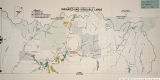
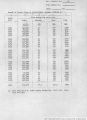
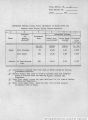
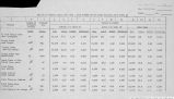
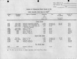
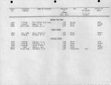
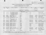
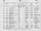
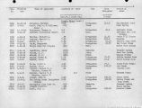
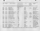
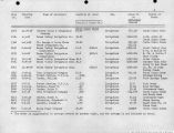
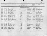
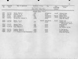
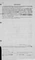
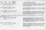
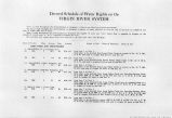
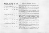
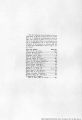
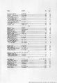
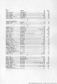
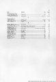
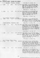
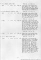
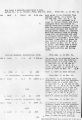
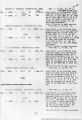
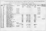
Show Date of Priority Class Acreage Duty Amount ASH CREEK AND TRIBUTARIES 88. WILLIAMS, JOHN D., Kanarra, Utah. 1880 1 26.4 60 0.44 c.f.s. 89. ROUNDY, JOEL J., Kanarra, Utah. . 1890 1 30.5 60 0.51 c.f.s. Period of Use. Point of Diversion. Place of Use. 20 90. DECKER, ORPHA, Parowan, Utah. Feb. 20, 1915 3 400.00 (Application No. 6069) (Proof Due Nov. 15, 1926) 6.0 c.f.s. 91. DRY CREEK FARM & IRRIGATION CO., S. L. Pollock, Mgr., Kanarra, Utah. 1896 2 963 60 1.67 c.f.s. 92. THORLEY, R. A., Cedar City, Utah. Jan. 26, 1911 3 52.38 1.05 c.f.s. (Application No. 4078) (Certificate No. 424) 93. SCHMUTZ, DONALD, New Harmony, Utah. July 31, 1913 3 .013 c.f.s. (Application No. 5382) (Certificate No. 281) 93A. SCHMUTZ, DONALD, New Harmony, Utah. Aug. 9, 1913 3 .0267 c.f.s. (Application No. 5395) (Certificate No. 282) 93B. SCHMUTZ, DONALD, New Harmony, Utah. Aug. 9, 1913 3 .0164 c.f.s. (Application No. 5396) (Certificate No. 283) from Mar. 1 to Oct. 15. Said water to be diverted from Camp Creek at a point 100 ft. S. and 350 ft. E. of the WJ4 Cor. of Sec. 10, T. 38 S., R. 12 W. and used to irrigate 26.4 acres described as follows: 19.8 acres in Sec. 10; 6.6 acres in Sec. 9, T. 38 S., R. 12 W. from Jan. 1 to Dec. 31. Said water to be diverted from Camp Creek at a point 100 ft. S. and 350 ft. E. of WH Cor. of Sec. 10, T. 38 S., R. 12 W. and used to irrigate 30.5 acres in Sec. 9, T. 38 S., R. 12 W. from Mar. 1 to July 31. '"'¦ I Said water to be diverted from Taylor Creek at a point which lies 3630 ft. N. ami 495 ft. E. of the NE Cor. of the NW/4 of Sec. 32, T. 38 S., R. 12 W., and conveyed V means of a ditch for a distance of 5,775 ft. and there used to irrigate 400 acres of land embraced in Sees. 29, 30 and 31, T. 38 S., R. 12 W., Salt Lake Base and Meridian. As much of said water as may be necessary will be used from Jan. 1 to Dec. 31, inclusive, of each year, for domestic purposes. from Mar. 1 to Oct. 1. ¦ •. ' Said water to be diverted from Dry Creek at-a point 3630 ft, N. and 495 ft. E. of the NJ4 Cor. of Sec. 32, T. 38 S,, R 12W. and used to irrigate 96.3 acres of land described as follows: 3.5 acres in Sec. 19; 55.7 acres in NEH and 37.2 acres in Wj4 SWJ4 Sec. 30, T. 38 S., R. 12 W, from Jan. 1 to Dec. 31. Said water to be diverted from Kanarra Creek at a point N. 47° W. 1962 ft. from the NJ4 Cor. of Sec. 31, T. 38 S., R. 12 W. and used to irrigate 52.38 acres cm-braced in Lots I, 2, 3 and 4 of said Sec. 31. from Mar. 1 to Dec. 31. Said water to be diverted from Lower Spring which is situated at a point N. 17° 07' E. 1320 ft. distant of the SlA Cor. of Sec. 36, T. 37 S., R. 13 W., Salt Lake Base and Meridian, where it issues from said spring and conveyed by means of a pipe line for a distance of 48 ft., and there used for stock watering purposos. from April 1 to Dec. 3J. Said water to be diverted from Middle Spring at a point which bears N. 21° W. 5720 ft. distant of the S}4 Cor. of Sec. 36, T. 37 S., R. 13 W. where it issues from said spring and conveyed by means of a ditch for a diseance of 150 ft., and there used for stock watering purposes. . Irons April 1 to Dec. 1. Said water to be diverted from an unnamed spring at a point S. 30s £. 4420 ft. from the SW Cor. of Sec. 35, T. 37. S., R. 13 W. and used for stock watering purposes. |