| OCR Text |
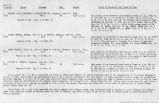
Show 256 IRRIGATION INVESTIGATIONS IN UTAH. The water supply in Long Valley is limited, there being, in the opinion of many of the farmers, but about one-half enough to irrigate the land now claiming a water right. July 2, 1902, East Fork, measured 300 yards above Glendale Dam, was carrying but 7.40 cubic feet per second. The total area watered in the three settlements is 1,104 acres, or approximately 150 acres to each cubic foot per second in the stream in the middle of the irrigation season. After May 1 water seldom flows down the stream out of Long Valley to the settlements below. MOUNT CARMEL. Mount Carmel is the lowest settlement in the valley. Two main ditches and one smaller one that collects the seepage water from the other two, aggregating 6 miles in length, water 422 acres. Water is distributed two and one-half hours to each acre every fourteen days. The annual assessment for ditch maintenance averages 50 cents per acre for the three ditches. The water at Mount Carmel is controlled by the Mount Carmel Irrigation Company, which was incorporated February 28, 1896, with a capital stock of $4,048.33, divided into 404.83 shares. Each share represents a water right for 1 acre of land. ORDERVILLE. At Orderville there is but one ditch, which is 2.5 miles long and waters 265.5 acres. The control of the water is in the Orderville Irrigation Company which was incorporated March 3, 1896, with a capital stock of $2,980, divided into 298 shares. The ditch assessment averages 60 cents per acre per year. GLENDALE. There are two ditches at Glendale-the Glendale East Ditch, 4 miles long, and watering 231 acres, and the Glendale West Ditch, 4 miles long, and watenug 203 acres. Water is distributed four hours to the acre under the east ditch and three hours to the acre under the west ditch. The water is controlled by the Glendale Irrigation Company, which was incorporated March 2, 1885, with a capital stock of $4,340, divided into 434 shares, each of which represents a right to water for 1 acre. The annual assessment for ditch maintenance averages 55 cents per acre. RANCHE. Above Glendale, and extending to Ranche, a series of eight small ditches irrigates 140 acres in holdings averaging 15 acres. The valley of the East Fork is very narrow and the irrigated areas much scattered. Considerable wild hay is grown, and also some alfalfa and small grain. Potatoes and hardy vegetables are the other products. WATER TITLES IN THE UPPER DIVISION. Water titles in Long Valley have, after some years of confusion, become quite well settled through a decree of the district court quieting title to the whole of East Fork from Ranche to and including Mount Carmel. This decree was rendered April 18, 1900, by Judge W. M. McCarty, in the case of the Mount Carmel Irrigation Company et aL v, L. J. Hopkins et al. Chamberlain.* Lake and Lydias Fork of East |
| Source |
Original book: Utah exhibits [of the] State of Arizona, complainant, v. State of California, Palo Verde Irrigation District, Imperial Irrigation District, Coachella Valley County Water District, the Metropolitan Water District of Southern California, City of Los Angeles, City of San Diego, and County of San Diego, defendants, United States of America and State of Nevada, interveners, State of New Mexico and State of Utah, parties |


