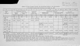
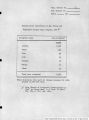
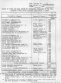
| OCR Text |
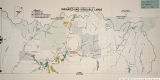
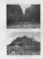
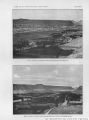
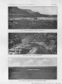
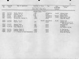
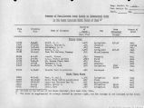
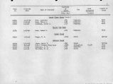
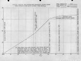
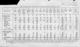
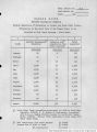
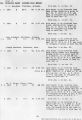
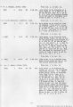
Show 224 IRRIGATION INVESTIGATIONS IN UTAH. MIDDI.ETON. Middleton, 2 miles east of St. George, gets water from Middleton Springs, for 35 acres, in holdings of 8.75 acres. There is no organization, and the annual cost of water is about 15 cents per acre. WASHINGTON. Washington is 5 miles east of St. George. The water supply comes from springs and Mill Creek, and is controlled by the town council of Washington and the Mill Creek Water Company. Water is distributed to 325 acres, by rotation. There are six ditches, having a total length of 4.5 miles. The water supply is generally sufficient. HARRISBCRO AND LEEDS. These settlements are on Quail Creek. The Leeds Water Company controls the water to irrigate 30 acres at Harrisburg and 230 acres at Leeds. Three ditches, having a total length of 7 miles, fu-nush a generally sufficient supply of water. June 18, 1902, Quail Creek waa carrying 4.97 cubic feet per second at Silver Reef above the division of the water to Harrisburg and Leeds. ANDERSONS. The Anderson Ditch waters from 1 to 150 acres from a spring, the area depending on the water supply, which is short. Fifty acres of orchard and vineyard received no water from January 1, 1900, to June 1, 1901, but were kept alive and thrifty by intensive cultivation. HARMONY. Harmony is located on the headwaters of North Ash Creek, and gets its water from that stream and springs. Nine ditches, with a total length of 5.5 miles, supply water to 305 acres in average holdings of 16 acres, at an annual cost of 50 to 75 cents per acre. On June 19, 1902, the following gaugings were made of Ash Creek, Lawson Spring, and Harmony Town Ditch, leading from Comanche Spring: Cu. ft. per see. North Ash Creek, 100 feet above upper dam below Harmony..................... 1.04 Lawson Spring Ditch, 200 yards below spring.....................................65 Harmony Town Ditch, at edge of F. Prince's field.................................49 Total.................................................................... 2.18 When these gaugings were made, Lawson Spring and Comanche Spring were normal. The main stream was approximately one-third of its flow April 15, 1902, when irrigation began, and twice the midsummer flow. The lowest duty of the water is therefore approximately 1 cubic foot per second to each 70 acres, and the highest duty 1 cubic foot per second to each 180 acres at Harmony. KANARBAVILLE. The Kanarra Field Reservior and Irrigation Company supplies water from Kanarra Creek to 350 acres, the average holdings being 12 acres. The water supply is very short. Water is delivered by time rotation, each acre receiving water two and one-half to four hours once in eight days. On June 19, 1902, Kanarra Creek was carrying 1.72 cubic feet per second, which was said to be the lowest flow for ten years, from one-fifth to one-tenth of the usual spring flow, and one-half of the usual summer flow. Because of the shortage, but 175 acres were being watered. BELLEVIK. Bellevue is located at the junction of South Ash and Ash creeks. The area irrigated is 75 acres in average holdings of 19 acres. On June 20, 1902, South Ash Creek was carrying 2.22 cubic feet per second, which was one-half the spring flow and twice the flow about August 1. TOQUEKVILLK. This settlement is on Ash Creek. Three hundred and fifty acres in average holdings of 6.5 acres are watered from Ash Creek and La Verkin Creek by six ditches, having a total length of 3 miles. The |
| Source |
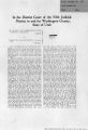
Original book: Utah exhibits [of the] State of Arizona, complainant, v. State of California, Palo Verde Irrigation District, Imperial Irrigation District, Coachella Valley County Water District, the Metropolitan Water District of Southern California, City of Los Angeles, City of San Diego, and County of San Diego, defendants, United States of America and State of Nevada, interveners, State of New Mexico and State of Utah, parties |