| Title |
Bulletin of the Geological and Geographical Survey of The Territories, Volume II |
| Subject |
Indians of North America--Dwellings; Archaeology; White people--Relations with Indians; Surveying; Federal government; Housing; Culture; Art; Language and languages; Navajo Indians; Ute Indians; Religion; Pottery; Plants; Indigenous peoples--North America |
| Keywords |
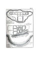
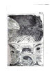
Indian; White Relations; Exploration; Trade; Cave Dwelling; Ojo Caliente; Aztec Springs; Tertiary Cretaceous; Native Americans |
| Publisher |
Digitized by J. Willard Marriott Library, University of Utah |
| File Name |
BULLETINOFTHEUNITEDSTATESGEOLOGICA.pdf |
| Tribe |
Navajo; Ute |
| Language |
eng |
| Description |
Vol. II, 528 p., written by F.V. Hayden, U.S. Geologist in Charge. Washington, Government Printing Office: 1876. Volume II |
| Type |
Text |
| Format |
application/pdf |
| Rights |
Digital Image © 2009 America West Center. All Rights Reserved. |
| ARK |
ark:/87278/s6jd7s6g |
| Creator |
Hayden, F. V. (Ferdinand Vandeveer), 1829-1887 |
| Date |
1876 |
| Spatial Coverage |
Arizona; Colorado; New Mexico; Utah |
| Setname |
uaida_main |
| ID |
358606 |
| Reference URL |
https://collections.lib.utah.edu/ark:/87278/s6jd7s6g |