| OCR Text |
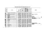
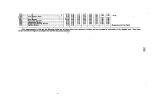
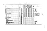
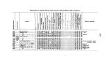
Show 224 To untangle this mass is an enormous labor, and one perplexing in the extreme. Many have undertaken it, and have given it up in despair. In 1874, Mr. J. T. Gardner, then connected with this Survey, undertook a part of this labor, and succeeded in carrying it through with a consid-erable degree of success. His problem was, to obtain the true elevation of Denver, Colo., which serves as a hypsometric base for our work in Colorado. To this end, he connected a number of lines from the Atlantic and Gulf coasts, rooted out nearly all the errors, and finally obtained results for the heights of several of the most important railroad- centers, which, from their close agreement, show a strong probability of being correct. Should these results, on the application of further tests, prove trustworthy, they will form a frame- work, by use of which the problem will be simplified very much. Elevations measured by barometer are liable to large errors, unless the work is done under the very best circumstances. The most potent causes of error are too great distance, horizontal and vertical, from the barometric base. In the earlier days of exploration in the West, it was impossible to obtain ev6n tolerable conditions for the execution of hypsometric work. Hence, naturally, the earlier measurements of elevations in the West are found to present a wide range of error, some being changed scarcely any by later and more reliable measurements, others being several hundreds of feet- indeed, in some cases reaching a thousand feet- from the truth. In constructing these curves, though I have made use of the many thousands of elevations in my possession, I have borne in mind that elevations of isolated points merely, without a knowledge of the surrounding topography, are of little use. Indeed, in many cases they are worse than useless, as they may tend to mislead. The mean heights of mountain- ranges have been expressed as nearly as possible. They will, no doubt, be subject to much criticism, as many of them are based on insufficient information, and my estimate of the mean heights of others, based on the heights of a few peaks, may not be correct. In the caiions of the Colorado and Green Rivers, I have thought best, j owing to the small scale of the map, to run the contours into a single line. The sources of information consulted and made use of in this work are almost numberless. I will enumerate the priucipal ones. For a knowledge of the Appalachian system and the country adjacent, I am indebted mainly to the article by Professor Guyot on the Appalachian system, published in vol. xxxi ( 1861) of Silliinan's Journal; also, in various State geological and geographical reports, there is much material of value concerning the Eastern States. Information concerning the valley of the Mississippi is scattered far and wide, and to specify authorities would fill a volume. Reports of State and General Government surveys and profiles of railroads have supplied the greater part of this information. On the slope of the great plains, between longitudes 96° and 104°, the contours are controlled largely by the plotted heights. These . heights have been collated from, first, the profiles of the several railroads which cross the plains, the Northern Pacific, Union Pacific, Burlington and Missouri River, Kansas Pacific, Atlantic and Pacific, Arkansas Valley, and others of less importance; and, second, from the profiles of the routes of the numerous expeditions which have crossed the plains in various directions. The Llano Estacado and the western part of Texas are known mainly |


