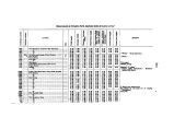
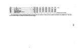
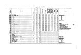
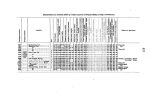
| OCR Text |
Show • 6 ments are BO frequently given on the plates themselves that no confusion need occur. Measurements were taken by tape- line in all the more important structures; but in many of the ordinary ruins, where exact dimensions were not considered essential, the distances were estimated. It is to be greatly regretted that extreme haste frequently prevented olose and accurate work. The accompanying map will give the location of all the more important groups of ruins. The fragments of information collected in this notice are given with the hope that they may throw a little additional light upou the very interesting problems of ancient American history. RUINED VILLAGE ON THE EIO LA PLATA. Plate I. The first group of ruins observed is situated on the Bio La Plata, about twenty- five miles above its junction with the San Juan, and three or four miles south of the New Mexican line. It is doubtless the reinaius of a large irregular village, and stands on a low terrace, some 20 feet above the river- bed, and near the center of a large fertile valley. It will be seen, by reference to the plate, which includes only the more important part of the town, that the buildings have been isolated, and, in a measure, independent of each other, differing in this respect from most of the groups of ruins farther south. The forms are chiefly rectangles and circles; one or two seem to have been elliptical, while a number have consisted of irregular groups or clusters of apartments. All that now remains to mark the site of these ancient structures is the low, rounded heaps and lines of iMbri*, composed of earth, water- worn pebbles, and small fragments of sandstone. The walls of four of the main structures are quite distinctly marked. That of the circle c is still 4 feet high on the outside, and incloses a depression, probably an ettufa, which, in the center, is 2 or 3 feet below the terrace-level. North of this, about 300 feet, is a truncated rectangular mound, 9 or 10 feet in height and 50 feet in width by 80 in length. Oo the east end, near one of the angles, is a low, projecting pile of debris that may have been a tower. Tbere is nothing whatever to indicate the use of this structure. Its flat top and height give it more the appearance of one of the sacrificial mounds of the Ohio Valley than any other observed in this part of the TV est. It may have been, however, only a raised foundation, designed to support a superstructure of wood or adobe. North of this again, and 100 feet distant, is a rectangular inclosure about 60 by 100 feet. It is slightly excavated in the center, and the rounded and irregular wall is from 4 to 6 feet in height. The space between this and the last- mentioned structure is filled in to the depth of 2 or 3 feet, and the amount of dSbris about their bases indicates original walls of considerable height. North of this are scattered a number of inferior ruins, the walls of which are not always distinctly marked. These extend back toward a row of low hills, the remnants of a superior terrace, on the summits of which a number of artificial depressions were found. Such " dug holes" are generally quite numerous in the vicinity of these ruins, and have doubtless in many cases been made by throwing up earthworks for defensive purposes. South of the large circle is a mass of ruins covering some 15,000 square feet, but so much reduced that nothing further could be determined than the fact that it had contained a large number of irregular apartments. Next to this is a rect- |


