| OCR Text |
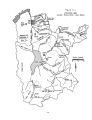
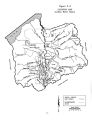
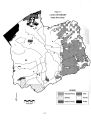
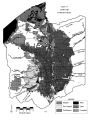
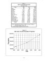
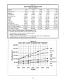
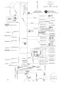
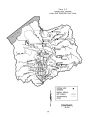
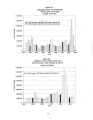
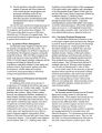
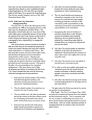
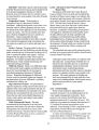
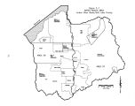
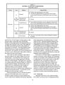
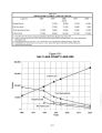
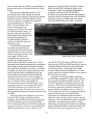
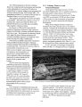
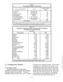
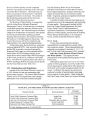
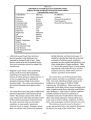
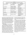
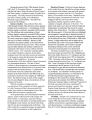
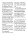
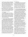
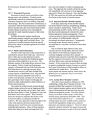
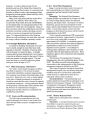
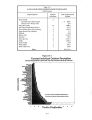
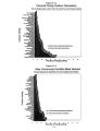
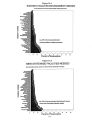
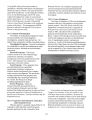
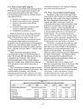
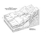
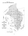
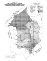
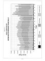
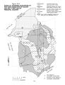
Show withdrawals. The Salt Lake Valley Interim Groundwater Management Plan was created to provide the necessary management guidelines until the USGS groundwater study is completed. The stated objective of the interim plan is to allow full utilization of the resources, within the constraint that water quality is not unreasonably affected. The Interim Groundwater Management Plan divides the valley into " management areas" and sets total groundwater withdrawals from the principal aquifer in each management area, as denoted on Figure 19- 3. The plan provides for further limitations on withdrawals if the cumulative effects unreasonably affect the water quality in the principal aquifer. The plan also limits applications to appropriate water from the principal aquifer to single family use ( 1.0 acre- foot per year) where public water systems are not available. The various management restrictions as dictated by the interim plan are represented in Table 19- 2. 19.4 Problems and Alternatives 19.4.1 Volume of Withdrawals One of the biggest concerns at the present time is the total volume of groundwater withdrawals. It is in the best interest of all water users that groundwater not be mined. Mining groundwater as defined herein means the withdrawal of more water than is naturally replaced over a long period of time, thereby lowering the hydrostatic water surface. Salt Lake Valley has an additional problem. Groundwater mining can potentially result in the contamination of the principal aquifer by inducing inflow of poorer quality water. Figure 19- 4 shows a summary of Salt Lake Valley well withdrawals for all uses for the 1963- 1995 period. Present groundwater withdrawals of 134,500 acre- feet ( 1986- 1995 average) are believed to be very close to the average annual yield of the principal aquifer. But there is a large amount of approved, unperfected water rights claims on Salt Lake Valley groundwater. If all are developed, total groundwater withdrawals would exceed 387,500 acre- feet, much higher than the estimated average annual recharge of the principal aquifer. 19.4.2 Groundwater Quality Groundwater contamination can be a very serious problem with potentially long- term consequences. Throughout Salt Lake Valley, many differing types of toxic materials are stored directly on the ground or underground in containment structures. These types of facilities can and have resulted in undetected or unreported hazardous material spills. Such spills can go undetected for a considerable time while the contamination spreads throughout the aquifer. Not only is the detection of such spills difficult but the clean up can be a very time- consuming and expensive process. Two such spills addressed in recent years are: ( 1) Contamination by leachate from the uranium- mill tailings of the Vitro- Chemical Co. at approximately 3300 South and 700 West in Salt Lake City, and ( 2) contamination of the Bingham Canyon and Bingham Creek area by seepage from reservoirs and evaporation ponds associated with Kennecott's Bingham Canyon mining activities. The Salt Lake Valley has been divided into five general areas of susceptibility to groundwater contamination based upon geology, the rate of groundwater movement and direction of vertical hydraulic gradients. These areas are shown on Figure 19- 5. Areas 1 and 2, which have the greatest susceptibility, are areas where contaminants can infiltrate directly to the principal aquifer without appreciable impediment by fine- grained deposits. Area 1 is the major recharge area for the principal aquifer with rapid groundwater velocity. An undetected spill of contaminant in Area 1 might percolate to the water table at considerable depth below the land surface and spread throughout a large area within the principal aquifer before being detected. Areas 3 and 4 are areas of intermediate to least susceptibility to contamination where the shallow unconfined and principal aquifers are separated by a confining layer, and the downward migration of contaminants is impeded by the finegrained materials in the confining layer. Also in Area 3, the vertical hydraulic gradient is either downward into the principal aquifer or is zero. In Area 4, the vertical hydraulic gradient is upward; therefore the susceptibility for vertical infiltration of contaminants under the present hydraulic regime is zero. Within each of the four areas, the presence or absence of confining layers may cause the classification shown to be in error; therefore, it is appropriate for use only as a general guideline. Area 5 denotes the areas of transition between areas of least susceptibility to contamination and the areas of intermediate 19- 5 |