| OCR Text |
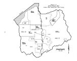
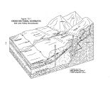
Show SECTION 19 STATE WATER PLAN - JORDAN RIVER BASIN GROUNDWATER Groundwater is an important source of water for municipal, industrial and agricultural uses in the Jordan River Basin. 19.1 Introduction This section describes groundwater conditions in the Jordan River Basin. Average groundwater withdrawals ( 1986- 1995) are currently estimated to be 134,500 acre- feet. The current developed groundwater supply is 168,500 acre- feet annually, or 26 percent of the presently developed water supply for municipal, industrial, irrigation, domestic and stock watering purposes. Groundwater in the valley's principal aquifer is generally of excellent quality on the east side of the valley, with the quality becoming poorer on the west side and towards the Great Salt Lake. The U. S. Geological Survey ( USGS), in cooperation with the Division of Water Rights, the Division of Water Quality, and the public water suppliers in the valley, is currently reporting on a study to determine the effects of groundwater withdrawals on water quality and to improve the existing groundwater model. The study was recently completed, but it is not yet published. Until this study is published, groundwater withdrawals will conform to the Salt Lake Valley Interim Groundwater Management Plan. not extend to the edges of the valley fill. Thus, near the mountain fronts, the principal aquifer is unconfined. 19.2.1 Recharge The main sources of Salt Lake Valley groundwater recharge are the Wasatch Range to the Ultraviolet sterilizers, Salt Lake County Water Conservancy District's Sandy Aquifer Storage Recovery System filtration building. 19.2 Subsurface Geology and Aquifer Characteristics The Salt Lake Valley groundwater basin consists of a principal aquifer of deep, unconsolidated materials, confined by a relatively thin layer of impervious soils, which in turn is overlaid by a shallow unconfined aquifer. Figure 19- 1 shows a cross- sectional view of the Salt Lake Valley groundwater regime. The confining layer of impervious soil is not continuous, more closely resembles a series of interlaced clay lenses, and does east, the Oquirrh Mountains to the west and the Traverse Mountains to the south. Lateral groundwater movement, depicted in Figure 19- 2, is from the mountains towards the center of the valley, then northerly to the Great Salt Lake. Sources of groundwater recharge include: ( 1) Seepage from mountain bedrock, ( 2) underflow in channel fill of mountain streams, ( 3) underflow from Utah Valley through the Jordan Narrows, ( 4) seepage from creek channels, ( 5) seepage from major canals, ( 6) seepage from irrigated fields, ( 7) seepage from lawns and gardens in urban and suburban areas, 19- 1 |


