| OCR Text |
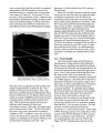
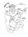
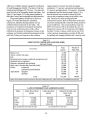
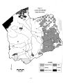
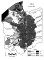
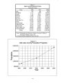
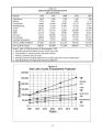
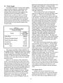
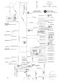
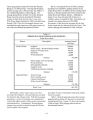
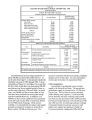
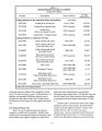
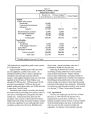
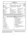
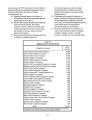
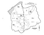
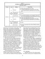
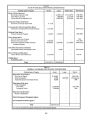
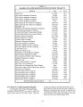
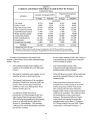
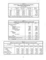
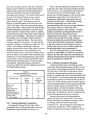
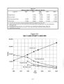
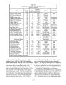
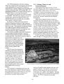
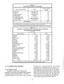
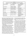
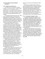
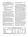
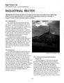
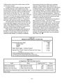
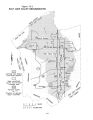
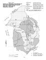
Show 5.3 Water Supply The Jordan River Basin's present water supplies come from three categories: groundwater, local surface water and imported surface water. An estimate of the total present water supply for the Jordan River Basin is presented in Table 5- 1. Imported water, as shown in Table 5- 2, includes deliveries directly by pipeline from Deer Creek Reservoir, Central Utah Project ( Bonneville Unit) deliveries from Jordanelle Reservoir, and Welby- Jacob Exchange water from Provo and Weber rivers and Echo Reservoir and industrial supplies from Tooele County. Table 5- 1 TOTAL WATER SUPPLY Jordan River Basin Source Average Annual Supply ( acre- feet) Jordan River 308,000 Wasatch Mountain streams 173,400 Oquirrh Mountain streams 4,400 Groundwater 168,500 Imported water 170,700 Total 825,000 The average annual flow of the Jordan River at the Jordan Narrows, including all diversions to canals, is 308,000 acre- feet. Additional surface water inflow between Jordan Narrows and the Great Salt Lake averages 173,400 acre- feet from the Wasatch Range mountain stream and 4,400 acre- feet from Oquirrh Mountain streams. Figure 5- 1 is a schematic of the Jordan River system. The horizontal line across the center of the page represents the Jordan River flowing from Utah Lake on the left to the Great Salt Lake on the right. Tributary flows from the Wasatch Range streams are represented by the vertical lines along the bottom of the figure. Irrigation withdrawals and culinary diversions for water treatment are shown. Despite irrigation and culinary withdrawals, the Wasatch Range streams are all shown as terminating at the Jordan River. On the other hand, the Oquirrh Mountain streams, except for Bingham Creek, are depicted as terminating short of the Jordan River ( See the upper center of Figure 5- 1). Because of the intermittent and ephemeral nature of these streams for much of the year, surface water flows often do not reach the Jordan River. Water storage in Deer Creek and Jordanelle reservoirs is represented in the lower left hand corner of Figure 5- 1. Water can be released from Deer Creek Reservoir to either the Provo River or the Salt Lake Aqueduct. The Salt Lake Aqueduct flow can be delivered to the Metropolitan Water Treatment Plant, the Southeast Regional Treatment Plant, the Draper Irrigation Company Treatment Plant, or diverted to the Jordan Aqueduct and conveyed to the Jordan Valley Water Treatment Plant. At the Olmsted Diversion, Provo River water can be diverted to the Jordan Aqueduct and conveyed to Jordan Valley Treatment Plant. A pump station gives the system increased flexibility, making it possible to pump water from the Jordan Aqueduct to the Salt Lake Aqueduct. Diversions from the Jordan River to various irrigation canals are shown. The figure also gives the location of the valley's water and wastewater treatment plants. Presently developed water supplies are summarized in Table 5- 2 and discussed in the following subsections. The valley's presently developed water supply is summarized by source in Table 5- 3. The developed water is segregated into two parts: The public water supply is shown first, and the privately developed water supply second. For the public water supply, the average annual supply is given as well as the reliable supply for nine out of 10 years. For planning purposes the reliable supply for nine out of 10 years is generally accepted as the firm yield. The basin's public water supply comes primarily from nine sources: City Creek, Parley's Creek, Big Cottonwood Creek, Little Cottonwood Creek, other small mountain streams, Welby- Jacob Exchange, Central Utah Project, Deer Creek Reservoir and groundwater. Shown second in the table are the privately developed water supplies including private domestic wells, stockwatering wells, irrigation water and industrial water. 5.3.1 Surface Water Surface water sources include flows from Wasatch Front mountain streams, Oquirrh Mountain streams and the Jordan River. Inflow to the Jordan River from Utah Lake averages 308,000 acre- feet. 5- 2 |