| OCR Text |
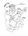
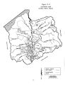
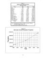
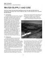
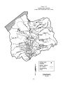
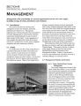
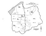
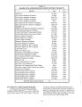
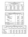
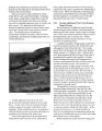
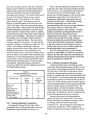
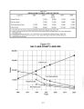
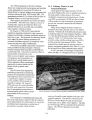
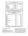
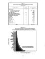
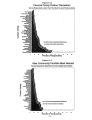
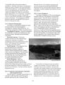
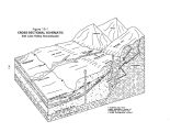
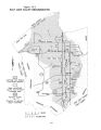
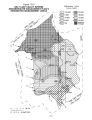
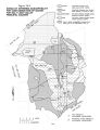
Show Basin, are located approximately 50 miles east of Salt Lake City in the western end of the Uinta Mountains in Wasatch County at elevations approaching 11,000 feet. In the upper reaches of the river, numerous small glacial lakes serve as catchment areas for the heavy snowfall and rain. The Provo River drains approximately 673 square miles of primarily mountainous and forested land which, except for the settlements in Heber Valley and Utah Valley, is sparsely populated. The other major drainage which contributes significant flows to Utah Lake is the Spanish Fork River which drains 652 square miles of mountainous and forested region in the southeast corner of the basin. Small basins to the west and south of Utah Lake are Cedar Valley, northern Juab Valley and Goshen Valley. These areas, along with other Utah Lake tributary streams, are discussed in the Utah Lake Basin Plan. The Jordan River is 44 miles long ( not including meanders) and flows north from the outlet of Utah Lake to the Great Salt Lake. It is also fed by seven major tributary streams ( Little Cottonwood Creek, Big Cottonwood Creek, Mill Creek, Parley's Creek, Emigration Creek, Red Butte Creek and City Creek) and 13 smaller streams which originate in the Wasatch Range on the east side of Salt Lake County. These furnish more than 97 percent of the surface water supply in the valley. Six other streams, which originate in the Oquirrh Mountains on the west side of the valley such as Bingham Creek and Butterfield Creek are intermittent and ephemeral in nature and supply less than 3 percent of the surface water. Salt Lake County has a total area of about 805 square miles ( 515,200 acres). Approximately 370 square miles are in the extremely mountainous and heavily forested Wasatch Range, Oquirrh Mountains and Traverse Mountains. With the exceptions of Emigration, Big Cottonwood and Little Cottonwood canyons, the mountainous areas are almost entirely uninhabited. Although there is very little residential or agricultural land use in the mountainous portions of the county, there are significant mining interests ( particularly in the Oquirrh Mountains) along with a tremendous amount of recreational activity ( Wasatch Range). Additionally, the Wasatch Range watersheds provide a significant portion of the municipal water supply. A topographical summary of Salt Lake County is given in Table 3- 1. Salt Lake County is home to just over 800,000 people, approximately 45 percent of Utah's total population, residing primarily in 14 incorporated cities ( Salt Lake City, South Salt Lake City, West Valley City, Sandy, Taylorsville, Murray, Midvale, Taylorsville, Draper, West Jordan, South Jordan, Riverton, Bluffdale and Alta). A significant population also lives in the unincorporated areas of the county. Much of the residential expansion is occurring on irrigated agricultural lands in the southwest portions of the valley. Utah Lake, which lies just south of the Jordan River Basin, is used as a reservoir. It has an active capacity of 710,000 acre- feet and a total capacity of 840,000 acre- feet at compromise. Utah Lake is nearly 300 feet higher than the Great Salt Lake, and the outflow from Utah Lake is the Jordan River. 3.3.2 Climate The Jordan River Basin climate is typical of mountainous areas in the west; wide ranges in temperature between summer and winter, and between day and night. The high mountain regions experience long, cold winters and short, cool summers. The lower valleys are more moderate with less variance between maximum and minimum temperatures. As part of the Great Basin Region lowlands, the Jordan River Basin is classified as semi- arid. The Jordan River Basin experiences four distinct seasons with a major portion of the precipitation occurring as snow during the winter months and producing high runoff during the spring snowmelt periods. Normal annual precipitation ranges from 12 to 16 inches on the valley floor to 60 inches in the high mountain areas of the Wasatch Range. Precipitation in the lower elevations during the May- September growing season is only 5 to 6 inches, compared to a crop water requirement of 20 to 30 inches. A portion of the precipitation on mountain ranges is absorbed into the soil and underlying bedrock during the runoff periods, providing recharge to the valley groundwater reservoir. Temperatures in the valley have ranged from - 30° F in the winter to 1 WY in the summer. Water surface evaporation in the valley averages 42 inches per year. The average frost- free season for the valley area is approximately 200 days from the middle of April to the end of October. 3.3.3 Physiography and Geology The Jordan River Basin forms part of the eastern edge of the Basin and Range Physiographic Province 3- 6 |