| OCR Text |
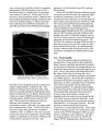
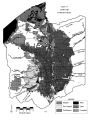
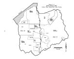
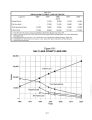
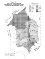
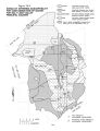
Show local flooding in the immediate area of the rupture and loss of culinary water supplies for several weeks to many months. Structural damage to one or more of the valley treatment plants would have a similar effect. Severe ground shaking throughout the valley could result in numerous local breaks to water lines, again resulting in local flooding followed by potentially long periods of water shortages. Another potential problem is ground subsidence in the northwest part of the valley in and around the airport and the Rose Park area. Geologic studies of the area show the potential for ground subsidence of several feet in the presence of severe ground shaking. Such an occurrence could result in the intrusion of Great Salt Lake waters into the area. 13.6.3 Landslides Landslides are most likely to occur along the foothills of the Wasatch Range or up one of the many canyons. Landslides can cover streams and/ or canals resulting in immediate flooding to areas upstream of the slide. Following such an event, there is also the threat that impounded water will overtop and wash out the slide material and result in severe flooding to areas immediately downstream. 13.7 Flood Prevention and Hazard Mitigation Flood hazard mitigation includes structural and non- structural activities that either eliminates or greatly reduces the impacts of flooding. Examples of structural mitigation measures include debris basins, dams, levees, various types of control structures and pipelines. Examples of non- structural mitigation activities are flood forecasting, zoning, flood plain protection and flood insurance. To be effective, flood hazard mitigation activities should be completed prior to the occurrence of a disaster. Flood hazard mitigation can also be thought of as a post- event activity. Managing agencies should use the lessons learned from recent events to prepare for and mitigate against possible recurrence. Utah's unprecedented floods of 1983 resulted in damages of nearly $ 500 million, much of it in the Jordan River Basin. Higher flows in 1984, however, amounted to only about one- sixth of those experienced in 1983. This was due in part to the mitigation efforts conducted after the 1983 event and prior to the 1984 flood. In just one year, the mitigation improvements prevented damages that far exceeded planning and construction costs. 13.7.1 Forecasting Peak flows in the Jordan River and its tributaries occur in the spring of the year and are primarily a function of snowmelt and runoff. These events can be forecasted with a fair degree of accuracy by monitoring the snow survey data. Forecasts can, in turn, be used to initiate flood preparations such as sandbagging. This process of forecasting and pre- flood preparations worked well to mitigate a great deal of potential flood damage in 1984 and 1986. 13.7.2 Flood Plain Zoning and Flood Insurance One of the most effective methods of mitigating or minimizing the effects of future flooding is through creation of and strict adherence to a flood plain zoning plan. County and city governments should work through the state Community Assistance Program of the National Flood Insurance Program to evaluate flood hazard maps of identified flood plains, and to enact appropriate zoning regulations to prevent further encroachment and thereby reduce the potential for flood damages. Most communities already have current maps and ordinances. In additional areas where national flood insurance can be made available by the adoption of the associated flood plain standards, local governments should attempt to do so. Also, public education and promotion of flood awareness would be beneficial. Salt Lake County and the various communities throughout the valley should be aggressive in regulating and limiting the construction of inappropriate and expensive developments in flood plains. Experiences nationwide have shown that when residential and commercial development takes place in the floodplain, catastrophic flooding leads to serious injuries, loss of life and significant economic impacts. The development of parks, golf courses, wetlands, wildlife preserves and other such uses within the flood plain can, however, be a beneficial use of those lands. As a protection against monetary losses when flooding occurs, the National Flood Insurance Program is effective in areas where it is available. The Federal Emergency Management Agency ( FEMA) has identified special hazard areas with flood insurance rate maps. Zoning and flood hazard reduction regulations have been adopted by these communities to direct future construction to minimize flood damage. A key benefit from local adoption of the floodplain standards has been the availability of 13- 4 |