| OCR Text |
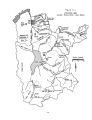
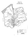
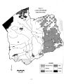
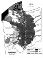
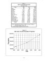
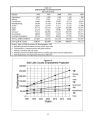
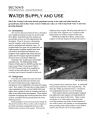
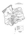
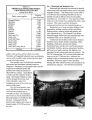
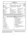
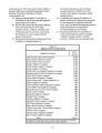
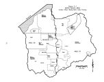
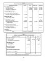
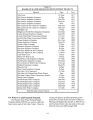
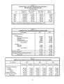
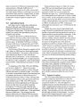
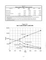
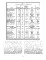
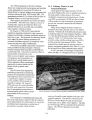
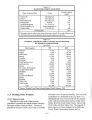
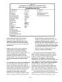
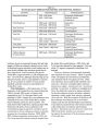
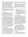
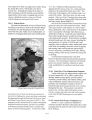
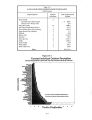
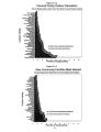
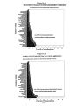
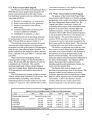
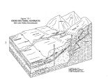
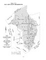
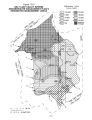
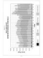
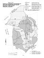
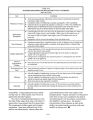
Show Table 3- 1 TOPOGRAPHY Salt Lake County Mountains (> 5200') Water ( including Great Salt Valley (< 5200') Total bounded on the east by the Wasatch Range of the Middle Rocky Mountains. The huge fault block mountains surrounding Salt Lake Valley stand as evidence of massive earth shifts in the past, and the Wasatch Fault exists today as a constant reminder of the areas turbulent past. In times of greater humidity and glacial activity, ancient Lake Bonneville covered over 20,000 square miles with a water level 1,000 feet above the present elevation of the Great Salt Lake. As the lake receded, it left wave cut terraces on the lower slopes of the mountains and deposits of sand and gravel in the valley. The basin is bounded on the east by the Wasatch Range which rises abruptly from the valley's edge ( approximately elevation 5,200) to 11,000+ feet above sea level. The Wasatch Range intercepts the moisture bearing westerly winds, providing the bulk of the valley's vital water supply. The Traverse Mountains form the valley's southern barrier. The western edge of the valley is bordered by the Oquirrh Mountains, whose peaks rise to 9,000- 10,000 feet. To the northwest lies the Great Salt Lake, and beyond that the Great Salt Lake Desert. 3.3.4 Soils and Vegetation The soils of the upper valleys, above elevation 5,200 ( the highest level of ancient Lake Bonneville), have developed from alluvial sediments on flood plains, alluvial fans, and foot slope areas at the base of the mountains. Quartzite and sandstones are the predominant parent material for the alluvium found in the upper valleys. Being so near the source of parent materials, the valley fill in the upper valleys consists mainly of coarse sands and gravels, although there are areas of medium to fine textured topsoils. Valley soils have developed from sediments deposited in ancient Lake Bonneville. Much of the soil is medium to coarse- textured material deposited 3- Area ( square miles) 370 26 409 805 at the edges of the valleys as fans. The lake terraces and finer materials widely distributed on the broader interior valley floor were deposited during Bonneville Lake and post- Bonneville Lake times. As a result, a complex pattern of highly stratified soils exists. In general, arable lands of the basin have good water transmission properties and adequate moisture- holding capacity which, with other favorable physical and chemical properties, make them well- suited for irrigated agriculture. As elevation varies from 4,200 to 11,000 feet, and precipitation varies from 12 inches to 60 inches, so also does vegetation vary. Heavy alpine forests above about 8,000 feet give way to oaks, mountain brush and juniper trees, then to sagebrush, sparse grasses, scattered vegetation and semi- desert conditions at lower elevations. About 30 percent of the county is forested with either alpine/ conifer/ aspen or oaks, with 27 percent falling into the closely related categories of mountain- brush, juniper, sagebrush, greasewood or native vegetation types. An additional 9 percent of the basin is classified as open water, riparian, marsh- land or wetlands. See Table 3- 2 for a detailed breakdown of the various vegetative cover types and land use. 3.3.5 Land Ownership And Use Most of the land in Salt Lake County, especially in the valley, is privately owned. Although Salt Lake City owns and manages 24,000 acres of the upper watershed, most of the lands in the upper watershed are managed by federal agencies. The biggest federal land manager is the Forest Service that administers 91,933 acres of national forest lands in the Wasatch Range. The next largest land holding federal agency is the U. S. Army which controls 13,988 acres around Camp Williams in the southern end of the valley. The only other significant federal land holding is |