| OCR Text |
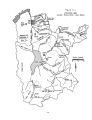
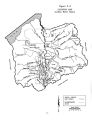
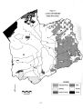
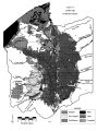
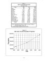
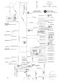
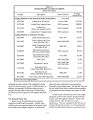
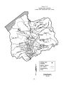
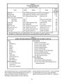
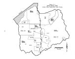
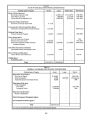
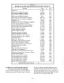
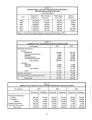
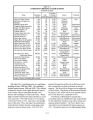
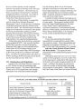
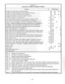
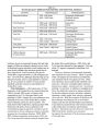
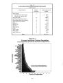
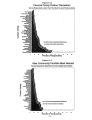
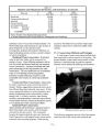
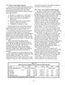
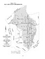
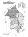
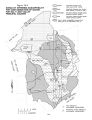
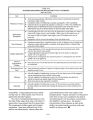
Show Table 12- 3 DIVISION OF WATER QUALITY SAMPLING SITES JORDAN RIVER SUB- BASIN INTENSIVE MONITORING STORET Number Sampling Site 499182 Jordan River at Cudahy Lane ( above South Davis WWTP) 499232 Jordan River at 1100 W 2100 S 499409 Jordan River below 6400 S at 1- 215 crossing 499417 Jordan River at 7800 S Crossing ( above South Valley WWTP) 499460 Jordan River at Bluffdale Road Crossing i 499195 City Creek above Filtration Plant 499210 RBII - Red Butte Creek ( above Red Butte Reservoir) 499216 Emigration Canyon Creek ( at switchback) 499220 Parleys Canyon Creek at Highway 65 crossing ( above Mountain Dell) 499222 Lambs Canyon Creek 499217 Mountain Dell Creek at Highway 65 crossing ( below Little Dell) 499219 Little Dell Creek at Highway 65 crossing ( above Little Dell) 499254 Mill Creek above Central Valley WWTP at 300 W 499264 Mill Creek at U. S. Forest Service boundary 499278 Mill Creek at Elbow Fork 499297 Big Cottonwood Creek above Jordan River at 500 W 499310 BC1 Big Cottonwood Creek at U. S. Forest Service Boundary 499323 BC9 Big Cottonwood Creek above confluence with Mill Creek 499358 Little Cottonwood Creek above Jordan River at 600 West 499366 Little Cottonwood Creek at U. S. Forest boundary \ 499378 Little Cottonwood Creek above confluence with Red Pine Creek lc3 499444 Butterfield Creek at mouth of canyon 499418 Bingham Creek above confluence with Jordan River 499472 Utah Lake at Narrows - below pump station The lower miles of the Jordan River are partially supporting for aquatic life. Problems include heavy algal blooms caused by excessive amounts of nutrients and dissolved oxygen depletions due to high BOD levels. Sources identified were urban runoff and municipal wastewater treatment plants. Mill Creek has been impacted by phosphorus and sediments. Some of the stream's riparian habitat has been lost and stream banks have been de- stabilized by recreational uses. Salt Lake County and the Forest Service are using the fees they collect to rehabilitate the stream banks. Picnic tables and campground areas are being moved away from the stream so that the riparian habitat can be re- established. The lower part of Big Cottonwood Creek, from the Forest Service boundaries to the Jordan River, have been labeled non- supporting because copper levels exceed the levels for aquatic life. The source appears to be the historic canyon mining sites. Little Cottonwood Creek from Jordan River to the Forest Service Boundary has fairly high levels of total dissolved solids and doesn't support its agricultural use classification. This is largely due to urban runoff. 12- 6 |