| OCR Text |
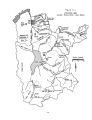
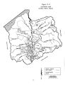
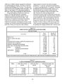
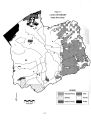
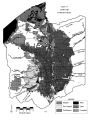
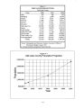
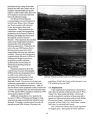
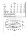
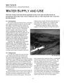
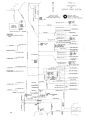
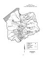
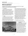
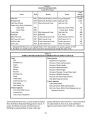
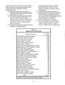
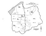
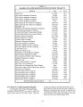
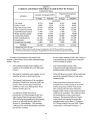
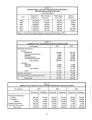
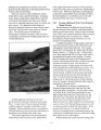
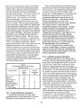
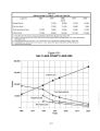
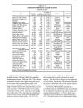
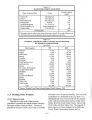
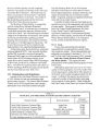
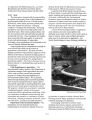
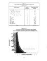
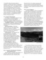
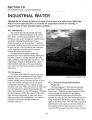
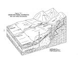
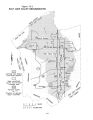
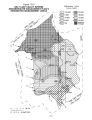
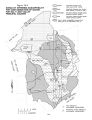
Show Although Salt Lake City owns and manages 24,000 acres of the upper watershed, most of the lands in the watershed are managed by federal agencies. The biggest federal land manager is the Forest Service, which administers 91,933 acres of national forest lands in the Wasatch Range. The state of Utah has scattered land holdings of 9,778 acres. The state also owns the beds of all navigable streams and lakes. The land- use data shown reveals that residential lands are clustered primarily on the eastern and central portions of the valley. Industrial lands are fairly well scattered throughout the valley with the most significant cluster in the northwest. Agricultural use is located in the southern and southwestern portions of the valley with some irrigated acres in the northwest. Conversion of irrigated agricultural land to residential use, primarily at the southern end of the valley, is the current trend. 2.4 Demographics and Economic Future Population, employment and the economy are discussed in this section. Salt Lake Valley, the major population and employment center in the state, is currently home to 805,000 residents. The population density for the county has grown from 900 people per square mile in 1990 to 995 people per square mile in 1995. Much of the county's rugged terrain, however, cannot be developed. Consequently it may be more appropriate to consider the population density of Salt Lake Valley which is currently approaching 2,000 people per square mile. The rate of growth through the year 2020 is expected to average 1.9 percent annually, but should range between 2.8 percent and 0.5 percent throughout the period. Projected population for the year 2020 is 1,300,100. Employment figures are projected to outstrip population growth at an annual growth rate of 2.31 percent. The overall pattern is a significant movement away from dependence on the state's traditional goods- producing economic base and toward service- producing industries as the driving sectors in the Utah economy. 2.5 Water Supply and Use Section 5 discusses the historical water supplies and present uses. The basin's water supply comes from groundwater, local surface water and imported water. Surface water sources include the Jordan River, Wasatch Range streams and Oquirrh Mountain streams. Imported water includes deliveries directly by pipeline from Deer Creek Reservoir, Central Utah Project ( Bonneville Unit) deliveries from Jordanelle Reservoir, and Welby- Jacob Exchange water from Provo and Weber Rivers and Echo Reservoir and industrial supplies from Tooele County. On an average annual basis these sources provide 825,000 acre- feet of water, of which approximately 661,000 acre- feet has been developed for culinary, commercial, industrial, agricultural and environmental uses. However, the basin's reliable water supply ( based upon 90 percent probability of availability) is 644,950 acre- feet and breaks down as follows: public drinking water systems - 333,150 acre- feet, private domestic systems - 24,600 acre- feet, self- supplied industrial systems - 39,700 acre- feet, agricultural water - 143,000 acre- feet, secondary non- potable water - 10,000 acre- feet, and developed wetlands - 94,500 acre- feet. 2.6 Management This section describes the existing water management systems for irrigation, municipal, industrial and wetland use. Management organizations are listed and general recommendations are made. To a large extent, the flow of the Jordan River is controlled at the point of outflow from Utah Lake. For the most part, the flow regimes within the Jordan River Basin are natural. Many of the Jordan River's tributary mountain streams tend to be intermittent ( and in many instances ephemeral, particularly on the west side of the valley) with flows ranging during the course of the year from zero to bank- full. The Jordan River Basin has 10 active reservoirs, but they are relatively small and located high in the Wasatch Range. Their primary function is culinary water supply storage. Their size and location preclude their use as flood control or flow management facilities. The overall management of water in the entire Jordan River Basin is complex requiring the integration of municipal, industrial, agricultural, and recreational needs as well as fish and wildlife issues. One of the biggest problems in the Jordan River Basin is the many competing values and interested parties, with no single controlling body or agency. Incorporated mutual irrigation companies serve the majority of irrigated land in the county. While these companies hold water rights for over 50,000 acres, recent land use surveys put existing irrigated 2- 2 |