| OCR Text |
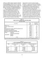
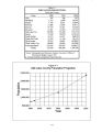
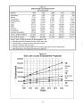
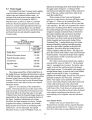
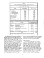
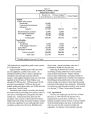
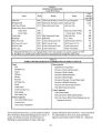
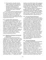
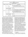
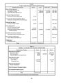
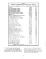
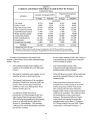
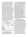
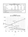
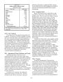
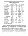
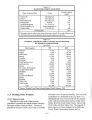
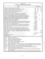
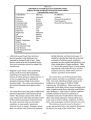
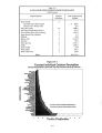
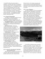
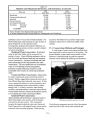
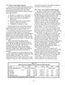
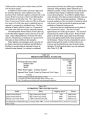
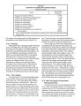
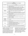
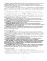
Show Table 19- 1 SUMMARY OF GROUNDWATER RECHARGE Jordan River Basin Annual Mean Source ( acre- feet) Seepage from mountain bedrock 135,000 Underflow in channel fill of mountain streams 1,500 Underflow through the Jordan Narrows i 2,500 Seepage from creek channels 20,000 Seepage from major canals 48,000 Seepage from irrigated fields 81,000 Seepage from lawns and gardens 17,000 Seepage from tailings ponds 2,400 Seepage from precipitation onto the valley floor 60,000 Total ( rounded) 367,000 Source: Technical Publication 31: Water Resources of Salt Lake County, State of Utah, Department of Natural Resources; 1971 ( 8) seepage from tailings ponds, and ( 9) seepage from precipitation on the valley floor ( See Table 19- 1). 19.2.2 Discharge Although the deep or principal aquifer is the main source of withdrawals in the valley, groundwater is also taken from the shallow unconfined aquifer and locally from unconfined perched water aquifers. All the unconsolidated water- bearing materials in the valley are connected hydraulically to some degree. Although water in each part of the groundwater reservoir has its own important role in the hydrologic regimen, the ultimate source of most of the groundwater withdrawn is the principal aquifer consisting of the confined portion of the principal aquifer and the deep unconfined portions of the principal aquifer along the ancient Lake Bonneville benches. Withdrawals from the principal aquifer are estimated to be 168,500 acre- feet of water annually. 19.2.3 Water Quality The water quality of the principal aquifer ranges from excellent on the eastern side of the valley to poor on the west. The water quality of the shallow, unconfined aquifer is generally poor. There is an upward gradient from the principal aquifer to the shallow aquifer over a large percentage of the valley. This helps maintain the high quality of the principal aquifer. Evidence indicates, however, that excessive pumping from the principal aquifer can reverse the upward gradient, allowing downward leakage of the poor quality water. This has happened locally in the past. Several portions of the principal aquifer are susceptible to contamination if the hydraulic gradient becomes reversed for a sufficient length of time. In low- lying parts of the valley, including most of the northern part and along the Jordan River, the potentiometric surface ( level at which water will stand in an open well) for the confined aquifer is above the land surface, causing wells to flow. The confined aquifer generally yields water readily to wells. The most productive wells are around the edge of the aquifer near the mountains where it contains thick, coarse- grained deposits. Most of the least productive wells are in the northern and central parts of the valley where the aquifer consists largely of finegrained deposits. The confined aquifer attains a maximum thickness of more than 1,000 feet in the northern part of the valley. Underlying the confined aquifer are relatively impervious semi- consolidated and consolidated rocks of Tertiary and pre- Tertiary age. The hydraulic connection between different water- bearing beds in the confined aquifer has been demonstrated many times during aquifer tests. 19.3 Salt Lake Interim Groundwater Management Plan The long- range planning and management of Salt Lake Valley's groundwater aquifer will ultimately be examined once the USGS groundwater study report is published. In the mean time, it is the opinion of the State Engineer that certain actions need to be taken now to ensure the valuable groundwater resources do not become contaminated as a result of excessive 19- 4 |