| OCR Text |
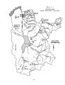
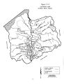
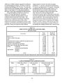
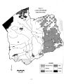
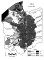
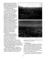
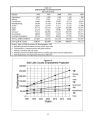
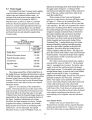
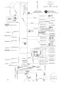
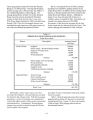
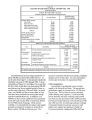
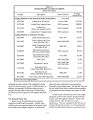
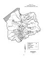
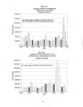
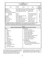
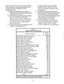
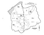
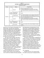
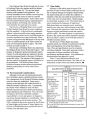
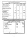
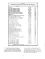
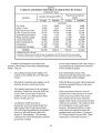
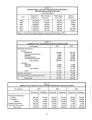
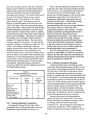
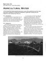
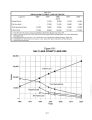
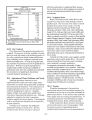
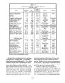
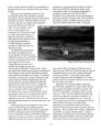
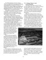
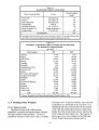
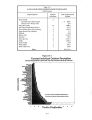
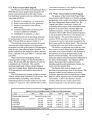
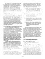
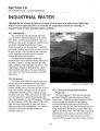
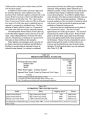
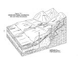
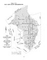
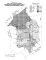
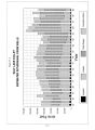
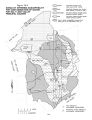
Show 2,896 acres of public domain managed by the Bureau of Land Management ( BLM). The state of Utah has scattered land holdings of 9,778 acres. The state also owns the beds of all navigable streams and lakes. See Table 3- 3 and Figure 3- 3 for the general pattern of Salt Lake County land ownership and administration. The general pattern of land use as shown on Figure 3- 4 reveals that lands for residential, commercial, industrial and agricultural uses are confined almost exclusively to the valley. The exceptions are industrial development in Bingham Canyon in the southwest portion of the valley, residential development in Emigration Canyon to the northeast, and limited residential development in Big and Little Cottonwood canyons in the southeast. Approximately 32 percent has been developed: residential, 17.2 percent; commercial and industrial, 4.5 percent; and agricultural, 10.3 percent. One detail not apparent from the land use map ( Figure 3- 4) is that recreational use is made of almost all of the canyon and mountainous areas on the valley's east side. Most heavily used are Big and Little Cottonwood canyons, both of which have world class ski resorts and spectacular vistas that attract people on a year- round basis. Also receiving heavy usage are Mill Creek Canyon with its developed day- use, and Emigration Canyon with its restaurants and lodging facilities. Parley's Canyon, which serves one of the valley's primary transportation corridors ( 1- 80), also has golfing and camping facilities and is heavily used Table 3- 2 VEGETATIVE COVER AND LAND USE ( 1988) Salt Lake County Cover/ Use Area ( acres) Percent of Total Area Barren rock 5,700 1.1 Alpine, conifer and aspen 76,500 14.8 Oak 87,700 15.3 Mountain brush, juniper, sagebrush and greasewood 62,400 12.1 Scattered native vegetation 79,700 15.5 Riparian, marshlands and wetlands 28,100 5.5 Open water ( Incudes the Great Salt Lake) 15,000 2.9 Urban: residential 92,800 18.0 commercial and industrial 23,400 4.5 ! Agricultural: irrigated 25,300 5.8 dry- farm 18,600 4.5 Total 515,200 100.00 Source: Water- Related Land Use Inventories, Division of Water Resources, 1994, and Division of Wildlife Resources data. Table 3- 3 LAND OWNERSHIP AND ADMINISTRATION Status Jordan River Basin ( acres) Utah Lake Basin ( acres) Jordan River/ Utah Lake Basin Total ( acres) Private State Federal Total 372,800 33,600a 108,800 515,200 866,400 233,900b 844,800 1,945,100 1,239,200 267,500 953,600 2,460,300 ( a): Includes be d of the Great Salt Lake ( b): Includes bed of Utah Lake 3- 8 |